IMAGES TAKEN NEAR TO
Cambridge Road, HARROW, HA2 7LB
Introduction
This page details the photographs taken nearby to Cambridge Road, HA2 7LB by members of the Geograph project.
The Geograph project started in 2005 with the aim of publishing, organising and preserving representative images for every square kilometre of Great Britain, Ireland and the Isle of Man.

There are currently over 7.5m images from over14,400 individuals and you can help contribute to the project by visiting https://www.geograph.org.uk
Image Map
Images are licensed for reuse under creativecommons.org/licenses/by-sa/2.0
Notes
- Clicking on the map will re-center to the selected point.
- The higher the marker number, the further away the image location is from the centre of the postcode.
Image Listing (48 Images Found)
Images are licensed for reuse under creativecommons.org/licenses/by-sa/2.0
Image
Details
Distance
6
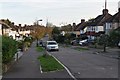
North Harrow: Northumberland Road
Viewed looking north westwards, at the crossing of Yeading Brook.
Image: © Nigel Cox
Taken: 20 Nov 2005
0.11 miles
9
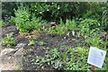
Streamside Rainbow Garden, Yeading Walk
This is a voluntary project where residents offer plants for the garden. It is in its early stages so long off its full future glory.
Image: © David Howard
Taken: 21 May 2020
0.13 miles
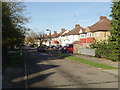
10
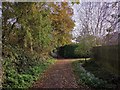
Footpath going past St John Fisher Catholic Primary School
Footpath joins together 3 residential roads.
Image: © James Emmans
Taken: 20 Nov 2019
0.13 miles