IMAGES TAKEN NEAR TO
Beechcroft Avenue, HARROW, HA2 7JF
Introduction
This page details the photographs taken nearby to Beechcroft Avenue, HA2 7JF by members of the Geograph project.
The Geograph project started in 2005 with the aim of publishing, organising and preserving representative images for every square kilometre of Great Britain, Ireland and the Isle of Man.

There are currently over 7.5m images from over14,400 individuals and you can help contribute to the project by visiting https://www.geograph.org.uk
Image Map
Images are licensed for reuse under creativecommons.org/licenses/by-sa/2.0
Notes
- Clicking on the map will re-center to the selected point.
- The higher the marker number, the further away the image location is from the centre of the postcode.
Image Listing (95 Images Found)
Images are licensed for reuse under creativecommons.org/licenses/by-sa/2.0
Image
Details
Distance
1
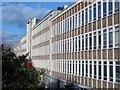
Office building, Imperial Drive (A4090), HA2
Image: © Mike Quinn
Taken: 2 Mar 2016
0.03 miles
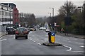
5
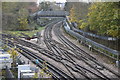
Metropolitan Line & Piccadilly Line merge
Image: © N Chadwick
Taken: 16 Nov 2019
0.08 miles
6
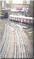
Piccadilly line and Metropolitan lines diverge/merge, Rayners Lane
Image: © N Chadwick
Taken: 3 Nov 2019
0.08 miles
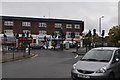
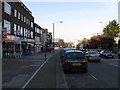
10
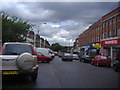
Shops along Rayner's Lane
This is the eastern edge of Pinner. Note the prominent Woolworths, now part of British history.
Image: © David Howard
Taken: 3 Jul 2008
0.09 miles