IMAGES TAKEN NEAR TO
Romney Drive, HARROW, HA2 7EQ
Introduction
This page details the photographs taken nearby to Romney Drive, HA2 7EQ by members of the Geograph project.
The Geograph project started in 2005 with the aim of publishing, organising and preserving representative images for every square kilometre of Great Britain, Ireland and the Isle of Man.

There are currently over 7.5m images from over14,400 individuals and you can help contribute to the project by visiting https://www.geograph.org.uk
Image Map
Images are licensed for reuse under creativecommons.org/licenses/by-sa/2.0
Notes
- Clicking on the map will re-center to the selected point.
- The higher the marker number, the further away the image location is from the centre of the postcode.
Image Listing (9 Images Found)
Images are licensed for reuse under creativecommons.org/licenses/by-sa/2.0
Image
Details
Distance
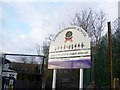
1
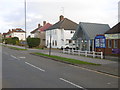
Elmfield Church, Imperial Drive
Elmfield Church is seen here from the central reservation of Imperial Drive. The church describes itself as "a friendly and growing multi-cultural evangelical church in North Harrow." For more information see http://www.elmfield.org/
Image: © Marathon
Taken: 23 Dec 2015
0.17 miles
2
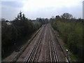
Westbound Tube lines, The Ridgeway West Harrow
Image: © David Howard
Taken: 22 Apr 2008
0.18 miles
3
St John Fisher Roman Catholic Church, Imperial Drive
St. John Fisher describes itself as "a large, lively Roman Catholic parish in the outer London suburb of Harrow." This photograph is from the corner of Imperial Drive and Imperial Close.
For more information see http://stjohnfisheronline.org.uk/
Image: © Marathon
Taken: 23 Dec 2015
0.20 miles
4
Eastbound Tube lines, The Ridgeway West Harrow
Image: © David Howard
Taken: 22 Apr 2008
0.20 miles
5
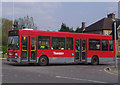
H11 bus leaving The Ridgeway
From Imperial Drive junction
Image: © David Howard
Taken: 22 Apr 2008
0.21 miles
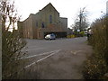
6
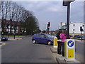
Imperial Drive junction of Village Way
Image: © David Howard
Taken: 22 Apr 2008
0.21 miles
7
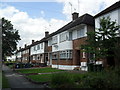
Imperial Close
1930s maisonettes in North Harrow.
Image: © Burgess Von Thunen
Taken: 20 Jun 2012
0.24 miles
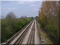
9
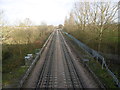
Metropolitan line from The Ridgeway
Metropolitan trains started running between Harrow-on-the-Hill and Uxbridge on 4th July 1904. Traffic was at first extremely disappointing. West Harrow halt was opened on 17th November 1913 as a response to house building west of Bessborough Road which had begun in about 1905. Within three years it was handling 40,000 passengers a month.
In this view from The Ridgeway West Harrow station is just beyond the bend in the distance. West Harrow Recreation Ground is to the right of the line. For more about West Harrow Recreation Ground see http://www.geograph.org.uk/photo/4773614
Image: © Marathon
Taken: 23 Dec 2015
0.25 miles