IMAGES TAKEN NEAR TO
Imperial Drive, HARROW, HA2 7DT
Introduction
This page details the photographs taken nearby to Imperial Drive, HA2 7DT by members of the Geograph project.
The Geograph project started in 2005 with the aim of publishing, organising and preserving representative images for every square kilometre of Great Britain, Ireland and the Isle of Man.

There are currently over 7.5m images from over14,400 individuals and you can help contribute to the project by visiting https://www.geograph.org.uk
Image Map
Images are licensed for reuse under creativecommons.org/licenses/by-sa/2.0
Notes
- Clicking on the map will re-center to the selected point.
- The higher the marker number, the further away the image location is from the centre of the postcode.
Image Listing (61 Images Found)
Images are licensed for reuse under creativecommons.org/licenses/by-sa/2.0
Image
Details
Distance
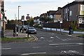
3
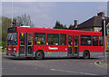
H11 bus leaving The Ridgeway
From Imperial Drive junction
Image: © David Howard
Taken: 22 Apr 2008
0.10 miles
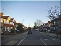
4

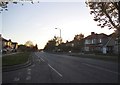
Imperial Drive, North Harrow
A view along Imperial Drive, looking towards North Harrow London Underground station. The station entrance is under the bridge, which carries Chiltern Railways trains as well as those of London Underground.
Image: © Malc McDonald
Taken: 29 Aug 2015
0.12 miles
6
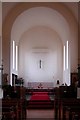
St Alban, The Ridgeway, North Harrow - Chancel
Image: © John Salmon
Taken: 3 Jun 2004
0.13 miles
8

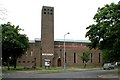
St Alban, The Ridgeway, North Harrow - West end
Image: © John Salmon
Taken: 3 Jun 2004
0.14 miles
9
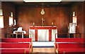
St Alban, The Ridgeway, North Harrow - Lady Chapel
Image: © John Salmon
Taken: 3 Jun 2004
0.14 miles