IMAGES TAKEN NEAR TO
Dorchester Avenue, HARROW, HA2 7AU
Introduction
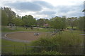
This page details the photographs taken nearby to Dorchester Avenue, HA2 7AU by members of the Geograph project.
The Geograph project started in 2005 with the aim of publishing, organising and preserving representative images for every square kilometre of Great Britain, Ireland and the Isle of Man.

There are currently over 7.5m images from over14,400 individuals and you can help contribute to the project by visiting https://www.geograph.org.uk
Image Map
Images are licensed for reuse under creativecommons.org/licenses/by-sa/2.0
Notes
- Clicking on the map will re-center to the selected point.
- The higher the marker number, the further away the image location is from the centre of the postcode.
Image Listing (118 Images Found)
Images are licensed for reuse under creativecommons.org/licenses/by-sa/2.0
Image
Details
Distance
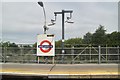
3
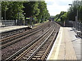
Underground train south west of West Harrow station
On its way to Rayners Lane station.
Image: © Nigel Thompson
Taken: 31 Jul 2018
0.08 miles
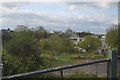
4
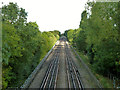
Metropolitan Line east of The Ridgeway
Looking towards West Harrow station, seen distantly on the curve.
Image: © Robin Webster
Taken: 29 Sep 2012
0.10 miles