IMAGES TAKEN NEAR TO
Kingsfield Avenue, HARROW, HA2 6AT
Introduction
This page details the photographs taken nearby to Kingsfield Avenue, HA2 6AT by members of the Geograph project.
The Geograph project started in 2005 with the aim of publishing, organising and preserving representative images for every square kilometre of Great Britain, Ireland and the Isle of Man.

There are currently over 7.5m images from over14,400 individuals and you can help contribute to the project by visiting https://www.geograph.org.uk
Image Map
Images are licensed for reuse under creativecommons.org/licenses/by-sa/2.0
Notes
- Clicking on the map will re-center to the selected point.
- The higher the marker number, the further away the image location is from the centre of the postcode.
Image Listing (16 Images Found)
Images are licensed for reuse under creativecommons.org/licenses/by-sa/2.0
Image
Details
Distance
4
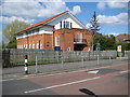
Headstone: St George's Hall
Grade II listed in 2006, the hall was built on the opposite side of Pinner View to Image, between 1928 and 1929, to the designs of the architect Cyril Arthur Farey.
Image: © Nigel Cox
Taken: 9 Apr 2008
0.16 miles
5
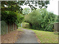
An entrance to Headstone Manor recreation ground
The way in from Parkside Way.
Image: © Robin Webster
Taken: 13 Oct 2012
0.19 miles
6
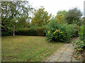
A partially neglected corner
A small and secluded area attached to Headstone Manor recreation ground, south of the Yeading Brook, of untrimmed hedges and overgrown paved paths, yet with a few small lawns still regularly mown.
Image: © Robin Webster
Taken: 13 Oct 2012
0.20 miles
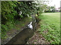
7
The Yeading Brook goes underground
It burrows under several streets of suburban housing before re-emerging.
Image: © Robin Webster
Taken: 13 Oct 2012
0.21 miles
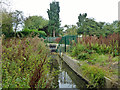
8
The Yeading Brook in Headstone Manor Recreation Ground
The land on which Headstone Manor stands was part of the complete manor of Harrow, owned by Wulfred, Archbishop of Canterbury in 825 AD. The house was originally completed in about 1345 and used as the Archbishops' main residence in Middlesex. Headstone Manor and its farm remained in the ownership of the church until the Reformation. It was sold by Henry VIII in 1547 to Lord Edward North and remained in private hands for four centuries.
Over time, Headstone Manor fell into a state of disrepair, and much of its surrounding land was sold off. In 1925 Hendon Rural District Council bought the site. It then passed into the control of the London Borough of Harrow after local government reorganisation.
Headstone Manor is the earliest surviving timber-framed building in Middlesex. The moat is contemporary in date to the earliest part of the building (about 1310) and is the only complete water-filled Medieval moat in Greater London. The brick facade was added in the 1770s, giving Headstone Manor the appearance it has today. With Heritage Lottery Funding, plans are in hand to restore the house and open it as a permanent museum in March 2017, telling the story of Harrow and of Headstone Manor.
This is the south-west corner of the park where the Yeading Brook can be seen. The Yeading Brook is a tributary of the River Crane. It has two branches. This, the longer northern branch, rises from the Headstone Manor moat and is also known as The Roxbourne river. It follows a meandering course through North Harrow, Rayners Lane, Ruislip, South Ruislip (skirting RAF Northolt as it does so where it joins the eastern branch of the Yeading Brook shortly thereafter), and onwards to Southall, before its confluence with the Crane at Hayes - see http://www.londonslostrivers.com/yeading-brook.html
Image: © Marathon
Taken: 25 May 2016
0.21 miles
9
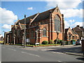
Headstone: Church of St George
The church was mainly built between 1910 and 1911 to the designs of the church architect John Samuel Alder. Alder's original design envisaged a tower at the near corner but this never came to fruition. After a break of some fifty years the church was completed and consecrated in 1961. The Church's website is here http://www.stgeorgeheadstone.org.uk/
Image: © Nigel Cox
Taken: 9 Apr 2008
0.22 miles
10
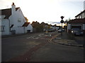
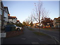
Kingsfield Avenue at the junction of Pinner View
Image: © David Howard
Taken: 11 Oct 2014
0.22 miles