IMAGES TAKEN NEAR TO
Sandpiper Drive, HARROW, HA2 0SF
Introduction
This page details the photographs taken nearby to Sandpiper Drive, HA2 0SF by members of the Geograph project.
The Geograph project started in 2005 with the aim of publishing, organising and preserving representative images for every square kilometre of Great Britain, Ireland and the Isle of Man.

There are currently over 7.5m images from over14,400 individuals and you can help contribute to the project by visiting https://www.geograph.org.uk
Image Map
Images are licensed for reuse under creativecommons.org/licenses/by-sa/2.0
Notes
- Clicking on the map will re-center to the selected point.
- The higher the marker number, the further away the image location is from the centre of the postcode.
Image Listing (24 Images Found)
Images are licensed for reuse under creativecommons.org/licenses/by-sa/2.0
Image
Details
Distance
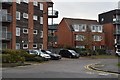
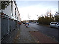
2
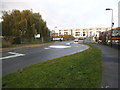
New flats on Rayners Lane
The construction continues on the right, there are windows in the hoardings and the shells are now complete before getting roofs and cladding.
Image: © David Howard
Taken: 20 Nov 2013
0.06 miles
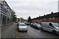
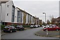
6
Rayners Lane
New flats have gone up on the left as far as the railway
Image: © David Howard
Taken: 20 Nov 2013
0.11 miles