IMAGES TAKEN NEAR TO
Roxeth Hill, HARROW, HA2 0JH
Introduction
This page details the photographs taken nearby to Roxeth Hill, HA2 0JH by members of the Geograph project.
The Geograph project started in 2005 with the aim of publishing, organising and preserving representative images for every square kilometre of Great Britain, Ireland and the Isle of Man.

There are currently over 7.5m images from over14,400 individuals and you can help contribute to the project by visiting https://www.geograph.org.uk
Image Map (64 Images)


Getting Data...Please wait
Leaflet Map data © OpenStreetMap
Images are licensed for reuse under creativecommons.org/licenses/by-sa/2.0
Notes
- Clicking on the map will re-center to the selected point.
- The higher the marker number, the further away the image location is from the centre of the postcode.
Image Listing (64 Images Found)
Images are licensed for reuse under creativecommons.org/licenses/by-sa/2.0
Image
Details
Distance
1
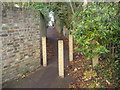
Footpath from Roxeth Hill to West Hill, Harrow
Image: © David Howard
Taken: 11 Dec 2008
0.01 miles
2
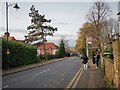
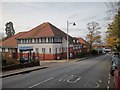
Roxeth Hill Bus Stop RH
The A4005 Main road.
Image: © James Emmans
Taken: 20 Nov 2019
0.02 miles
3
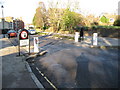
Harrow on the Hill: London Road
As its name suggests this was once the main road through Harrow on the Hill. This width restriction slows down northbound motorists as they approach Image
Image: © Nigel Cox
Taken: 2 Jan 2010
0.07 miles
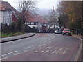
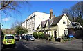
5
Harrow on the Hill YMCA
Christ Church is behind the YMCA.
Image: © James Emmans
Taken: 20 Nov 2019
0.09 miles
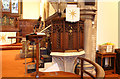
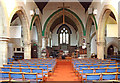
7
Christ Church, Roxeth Hill - Stained glass window
Image: © John Salmon
Taken: 18 Jan 2016
0.10 miles
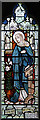
8
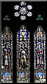
Christ Church, Roxeth Hill - Stained glass window
Image: © John Salmon
Taken: 18 Jan 2016
0.10 miles
10
London Road, Harrow on the Hill
The Capital Ring path goes along here through Harrow.
Image: © Des Blenkinsopp
Taken: 4 Nov 2014
0.10 miles