1
Harrow on the Hill: The former King's Head public house
This former public house and hotel is believed to have been built in the late 18th century on the site of King Henry VIII's hunting lodge. It survived until about 2001 before being converted into flats. Numerous blogs have blamed the council for allowing the conversion of this historic and well-remembered landmark and the loss of much of its fine and interesting interior. The carved words "King's Head Hotel" can just about be picked out in the white rendered stonework of the parapet wall of the section of the building to the right.
Image: © Nigel Cox
Taken: 2 Jan 2010
0.02 miles
2
Harrow old fire station
Harrow old fire station, 88-90 High Street, Harrow, is now used as an estate agent's office. The face of the clock on the top is marked 'The Old Fire Station' to give passers by a clue (although it took me about 5 minutes to locate the correct building!)
Image: © Kevin Hale
Taken: 26 Nov 2007
0.03 miles
3
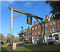
The King's Head Sign
On a small green beside Harrow High Street this sign still hangs opposite the old Kings Head pub.
The pub itself has closed and been turned into housing.
Image: © Des Blenkinsopp
Taken: 4 Nov 2014
0.03 miles
4
Harrow on the Hill: The Old Fire Station and Local Board Office
The old fire station, on the right, was designed by Charles F Hayward and built at a cost of £2,000 in 1888. It was in use until 1963.
Image: © Nigel Cox
Taken: 2 Jan 2010
0.05 miles
5
Harrow on the Hill: High Street
This area is inside the Harrow on the Hill Village Conservation Area and all the buildings visible in the image are Locally Listed. The spire of
Image is just visible to the left of the end of the buildings.
Image: © Nigel Cox
Taken: 2 Jan 2010
0.05 miles
6
Harrow on the Hill - Bryon Hill Road
Old cottages on a steep hill taken with a wide angle lens make the photo look slightly strange.
Image: © James Emmans
Taken: 20 Nov 2019
0.06 miles
7
Harrow on the Hill: The Old Etonian
Droll humour with the naming of this restaurant on the High Street. Note the fine photographic composition with the spire of Harrow on the Hill church coming straight out of the chimneys at the end of the terrace! Doh!
Image: © Nigel Cox
Taken: 12 Nov 2005
0.06 miles
8
Harrow on the Hill. Middlesex
Complete with schoolboy in traditional 'boater'. Only one motor car visible in this 1956 picture. This is High Street, and the junction with West Street is on the left just before reaching the clock. The spire visible is that of the Parish and Borough Church of St. Mary.
Image: © Dr Neil Clifton
Taken: 13 May 1956
0.06 miles
9
High Street, Harrow on the Hill, Middlesex
This view is looking southwards along that part of the High Street south of the West Street junction
Image: © Dr Neil Clifton
Taken: 13 Mar 2007
0.06 miles
10
South end of High Street, Harrow on the Hill, Middlesex
This is looking southwards at the south end of High Street, not far from the Kings Head hotel
Image: © Dr Neil Clifton
Taken: 13 Mar 2007
0.07 miles


