IMAGES TAKEN NEAR TO
Waldron Road, HARROW, HA2 0HU
Introduction
This page details the photographs taken nearby to Waldron Road, HA2 0HU by members of the Geograph project.
The Geograph project started in 2005 with the aim of publishing, organising and preserving representative images for every square kilometre of Great Britain, Ireland and the Isle of Man.

There are currently over 7.5m images from over14,400 individuals and you can help contribute to the project by visiting https://www.geograph.org.uk
Image Map
Images are licensed for reuse under creativecommons.org/licenses/by-sa/2.0
Notes
- Clicking on the map will re-center to the selected point.
- The higher the marker number, the further away the image location is from the centre of the postcode.
Image Listing (146 Images Found)
Images are licensed for reuse under creativecommons.org/licenses/by-sa/2.0
Image
Details
Distance
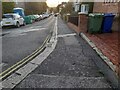
1
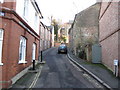
Harrow on the Hill: Waldron Road
Waldron Road has to be one of the narrowest two-way through roads in the country, which coupled with the steepness of the hill makes driving a little difficult. The distance from kerb to kerb is only about 4 metres. The terraced houses on the right are original, those on the left quite modern (they are not shown on the Ordnance Survey map of 1935 for example), but built in the style of the originals. Image is to the left.
Image: © Nigel Cox
Taken: 2 Jan 2010
0.01 miles
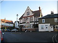
2
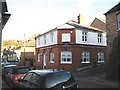
Harrow on the Hill: The former North Star public house
According to one source on the internet this fine former Edwardian corner pub, with its original attractive Benskin's Brewery signage, closed as long ago as 1957. It is now a private residence. Crown Street, formerly known as Hogarth Lane, runs right to left while Image leaves to the right.
Image: © Nigel Cox
Taken: 2 Jan 2010
0.02 miles
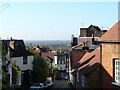
3

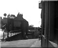
Harrow on the Hill, Middlesex
High Street curves round to the left, and West Street is straight on downhill, in this 1956 view.
Image: © Dr Neil Clifton
Taken: 13 May 1956
0.02 miles
4
West Street, Harrow on the Hill, Middlesex
It's a sunny Sunday afternoon in May, 1956, and a Harrow schoolboy, with traditional 'boater', makes his way up West Street. Not a motor car in sight!
Image: © Dr Neil Clifton
Taken: 13 May 1956
0.02 miles
5
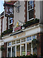
The Castle, Harrow on the Hill
This grade II listed Fuller's pub on West Street is notable for its characterful interior.
Image: © Stephen McKay
Taken: 22 Oct 2011
0.03 miles
7

The old 'North Star', Harrow-on-the-Hill
Now a private residence, but the owners have taken care to maintain much of the building's character - as 'streetscape'. The brewers' name is still there - perhaps tiled, Looking closer, I found that the windows were engraved - 'Lounge', 'Saloon Bar', 'Public Bar'.
Image: © Stefan Czapski
Taken: 28 Mar 2022
0.04 miles
8
Harrow on the Hill: The Castle
The Castle is a traditional Fuller's outlet on West Street at its junction with Crown Street. The date in the gable reads 1901, so the architectural style is late Victorian and merits Grade II Listed Building status. The pub sign has an interesting play on the pub's name by using a picture of a chess piece rather than some mediaeval fortress.
Image: © Nigel Cox
Taken: 2 Jan 2010
0.05 miles
10
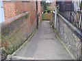
Path from West Street, Harrow on the Hill
Leading to the playing fields behind
Image: © David Howard
Taken: 17 Feb 2009
0.06 miles