IMAGES TAKEN NEAR TO
Porlock Avenue, HARROW, HA2 0AP
Introduction
This page details the photographs taken nearby to Porlock Avenue, HA2 0AP by members of the Geograph project.
The Geograph project started in 2005 with the aim of publishing, organising and preserving representative images for every square kilometre of Great Britain, Ireland and the Isle of Man.

There are currently over 7.5m images from over14,400 individuals and you can help contribute to the project by visiting https://www.geograph.org.uk
Image Map
Images are licensed for reuse under creativecommons.org/licenses/by-sa/2.0
Notes
- Clicking on the map will re-center to the selected point.
- The higher the marker number, the further away the image location is from the centre of the postcode.
Image Listing (25 Images Found)
Images are licensed for reuse under creativecommons.org/licenses/by-sa/2.0
Image
Details
Distance
4
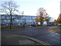
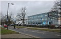
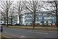
Whitmore High School on Porlock Avenue
Image: © David Howard
Taken: 20 Nov 2013
0.05 miles
6
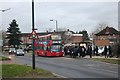
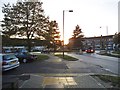
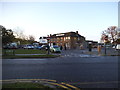
Whitmore High School, Harrow
The 114 bus collects the hundreds of children pouring out of the school just on the right. Shaftesbury Circle is ahead.
Image: © David Howard
Taken: 16 Dec 2019
0.07 miles
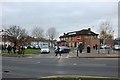
9
McDonald's on Porlock Avenue
Many pubs in North London are now McDonald's, this looks like another example.
Image: © David Howard
Taken: 20 Nov 2013
0.08 miles