IMAGES TAKEN NEAR TO
The Gardens, HARROW, HA1 4WJ
Introduction
This page details the photographs taken nearby to The Gardens, HA1 4WJ by members of the Geograph project.
The Geograph project started in 2005 with the aim of publishing, organising and preserving representative images for every square kilometre of Great Britain, Ireland and the Isle of Man.

There are currently over 7.5m images from over14,400 individuals and you can help contribute to the project by visiting https://www.geograph.org.uk
Image Map
Images are licensed for reuse under creativecommons.org/licenses/by-sa/2.0
Notes
- Clicking on the map will re-center to the selected point.
- The higher the marker number, the further away the image location is from the centre of the postcode.
Image Listing (104 Images Found)
Images are licensed for reuse under creativecommons.org/licenses/by-sa/2.0
Image
Details
Distance
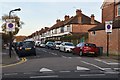
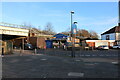
1
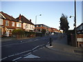
Pinner Road at the junction of The Gardens
Image: © David Howard
Taken: 11 Oct 2014
0.02 miles
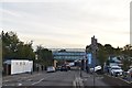
5
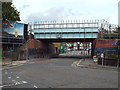
Railway bridge over The Gardens, Harrow
The railway bridge carries London Underground's Metropolitan Line. It is also used by Chiltern Railways trains between London Marylebone and Aylesbury.
The sign on the bridge prohibits vehicles more than 4.2 metres (13 feet 9 inches) high from attempting to pass beenath it.
Image: © Malc McDonald
Taken: 29 Aug 2015
0.05 miles
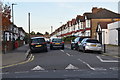
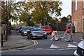
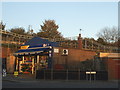
8
The Gardens, Harrow
The Metropolitan Line branch to Amersham crosses the road.
Image: © David Howard
Taken: 9 Dec 2021
0.06 miles
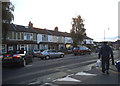
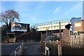
10
Shop and railway line on The Gardens, North Harrow
Image: © David Howard
Taken: 28 Oct 2014
0.07 miles