IMAGES TAKEN NEAR TO
Neptune Road, HARROW, HA1 4HX
Introduction
This page details the photographs taken nearby to Neptune Road, HA1 4HX by members of the Geograph project.
The Geograph project started in 2005 with the aim of publishing, organising and preserving representative images for every square kilometre of Great Britain, Ireland and the Isle of Man.

There are currently over 7.5m images from over14,400 individuals and you can help contribute to the project by visiting https://www.geograph.org.uk
Image Map
Images are licensed for reuse under creativecommons.org/licenses/by-sa/2.0
Notes
- Clicking on the map will re-center to the selected point.
- The higher the marker number, the further away the image location is from the centre of the postcode.
Image Listing (59 Images Found)
Images are licensed for reuse under creativecommons.org/licenses/by-sa/2.0
Image
Details
Distance


5
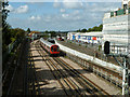
Metropolitan Line west of Harrow-on-the-Hill
The flying junction is seen, where the Uxbridge line burrows under the main line to head left. Northbound and southbound main line S8 stock trains are seen, with the nearer northbound one bound for Watford.
Image: © Robin Webster
Taken: 29 Sep 2012
0.06 miles