IMAGES TAKEN NEAR TO
Sumner Road, HARROW, HA1 4BU
Introduction
This page details the photographs taken nearby to Sumner Road, HA1 4BU by members of the Geograph project.
The Geograph project started in 2005 with the aim of publishing, organising and preserving representative images for every square kilometre of Great Britain, Ireland and the Isle of Man.

There are currently over 7.5m images from over14,400 individuals and you can help contribute to the project by visiting https://www.geograph.org.uk
Image Map (Loading...)


Getting Data...Please wait
Leaflet Map data © OpenStreetMap
Images are licensed for reuse under creativecommons.org/licenses/by-sa/2.0
Notes
- Clicking on the map will re-center to the selected point.
- The higher the marker number, the further away the image location is from the centre of the postcode.
Image Listing (111 Images Found)
Images are licensed for reuse under creativecommons.org/licenses/by-sa/2.0
Image
Details
Distance
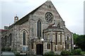
3
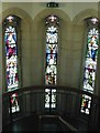
St Peter, Sumner Road, Harrow - Windows
West entrance
Image: © John Salmon
Taken: 3 Jun 2004
0.02 miles
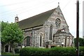
4
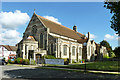
St Peter's, West Harrow
Between Sumner and Colbeck Roads.
Image: © Robin Webster
Taken: 29 Sep 2012
0.03 miles
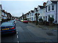
5
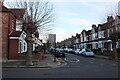
Butler Road at the junction of Drury Road
Image: © David Howard
Taken: 9 Dec 2021
0.06 miles
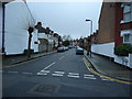
6
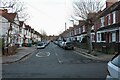
Heath Road at the junction of Drury Road
Image: © David Howard
Taken: 9 Dec 2021
0.07 miles