IMAGES TAKEN NEAR TO
Whitmore Road, HARROW, HA1 4AG
Introduction
This page details the photographs taken nearby to Whitmore Road, HA1 4AG by members of the Geograph project.
The Geograph project started in 2005 with the aim of publishing, organising and preserving representative images for every square kilometre of Great Britain, Ireland and the Isle of Man.

There are currently over 7.5m images from over14,400 individuals and you can help contribute to the project by visiting https://www.geograph.org.uk
Image Map
Images are licensed for reuse under creativecommons.org/licenses/by-sa/2.0
Notes
- Clicking on the map will re-center to the selected point.
- The higher the marker number, the further away the image location is from the centre of the postcode.
Image Listing (63 Images Found)
Images are licensed for reuse under creativecommons.org/licenses/by-sa/2.0
Image
Details
Distance
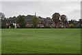
2
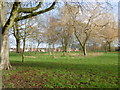
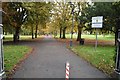
West Harrow Recreation Ground
West Harrow Recreation Ground dates from between the two World Wars but many of its its trees predate the park layout. The area was predominantly rural before the arrival of the railway brought housing development. The Metropolitan Railway extended the line from Harrow-on-the-Hill to Uxbridge in 1904. Traffic was at first extremely disappointing. West Harrow halt was opened on 17th November 1913 as a response to house building west of Bessborough Road which had begun in about 1905. Within three years it was handling 40,000 passengers a month. As housing grew up the park was provided for the new residential population. The houses in the distance are in Drury Road.
For more information see http://www.londongardensonline.org.uk/gardens-online-record.asp?ID=HRW055
Image: © Marathon
Taken: 23 Dec 2015
0.11 miles
3
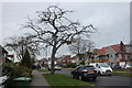
West Harrow: Drury Road
Viewed looking northwards from near the junction with Whitmore Road this pleasant tree-lined street is typical of this part of West Harrow.
Image: © Nigel Cox
Taken: 12 Nov 2005
0.11 miles

6
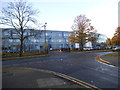
Whitmore High School on Porlock Avenue
Image: © David Howard
Taken: 20 Nov 2013
0.14 miles

8
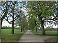
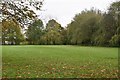
West Harrow Recreation Ground
Old Ordnance Survey maps available online show this whole area as open fields right up to the Edition of 1920. The Metropolitan Railway was the first significant development across the agricultural land and the Recreation Ground first appears, in a currently available online map, in the Edition of 1935.
The horse chestnut trees on the right are bursting into leaf.
Image: © Nigel Cox
Taken: 9 Apr 2008
0.15 miles