IMAGES TAKEN NEAR TO
High Street, HARROW, HA1 3HT
Introduction
This page details the photographs taken nearby to High Street, HA1 3HT by members of the Geograph project.
The Geograph project started in 2005 with the aim of publishing, organising and preserving representative images for every square kilometre of Great Britain, Ireland and the Isle of Man.

There are currently over 7.5m images from over14,400 individuals and you can help contribute to the project by visiting https://www.geograph.org.uk
Image Map
Images are licensed for reuse under creativecommons.org/licenses/by-sa/2.0
Notes
- Clicking on the map will re-center to the selected point.
- The higher the marker number, the further away the image location is from the centre of the postcode.
Image Listing (137 Images Found)
Images are licensed for reuse under creativecommons.org/licenses/by-sa/2.0
Image
Details
Distance
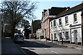
1
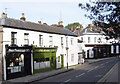
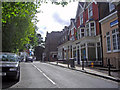
Harrow on the Hill: The Old Etonian
Droll humour with the naming of this restaurant on the High Street. Note the fine photographic composition with the spire of Harrow on the Hill church coming straight out of the chimneys at the end of the terrace! Doh!
Image: © Nigel Cox
Taken: 12 Nov 2005
0.02 miles
2
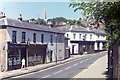
Harrow on the Hill. Middlesex
Complete with schoolboy in traditional 'boater'. Only one motor car visible in this 1956 picture. This is High Street, and the junction with West Street is on the left just before reaching the clock. The spire visible is that of the Parish and Borough Church of St. Mary.
Image: © Dr Neil Clifton
Taken: 13 May 1956
0.02 miles
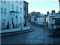
3
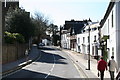
High Street, Harrow on the Hill, Middlesex
This view is looking southwards along that part of the High Street south of the West Street junction
Image: © Dr Neil Clifton
Taken: 13 Mar 2007
0.02 miles
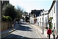
4
The High Street
Viewed from the other side of the street, West Street dropping away to the left, and Harrow Church spire in the background
Image: © Carl Grove
Taken: 5 Aug 1995
0.03 miles
6
Peterborough Road, Harrow on the Hill - looking south west
On a cold and frosty morning, a day with a top temperature of around two degrees centigrade.
Image: © Peter S
Taken: 10 Dec 2022
0.03 miles
7
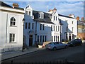
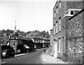
Harrow on the Hill: The former King's Head public house
This former public house and hotel is believed to have been built in the late 18th century on the site of King Henry VIII's hunting lodge. It survived until about 2001 before being converted into flats. Numerous blogs have blamed the council for allowing the conversion of this historic and well-remembered landmark and the loss of much of its fine and interesting interior. The carved words "King's Head Hotel" can just about be picked out in the white rendered stonework of the parapet wall of the section of the building to the right.
Image: © Nigel Cox
Taken: 2 Jan 2010
0.06 miles
8
Harrow-on-the-Hill: High Street
Looking south from the junction with West Street
Image: © Dr Neil Clifton
Taken: 13 Mar 2007
0.06 miles
9
South end of High Street, Harrow on the Hill, Middlesex
This is looking southwards at the south end of High Street, not far from the Kings Head hotel
Image: © Dr Neil Clifton
Taken: 13 Mar 2007
0.06 miles
10
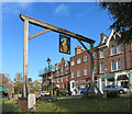
The King's Head Sign
On a small green beside Harrow High Street this sign still hangs opposite the old Kings Head pub.
The pub itself has closed and been turned into housing.
Image: © Des Blenkinsopp
Taken: 4 Nov 2014
0.06 miles