IMAGES TAKEN NEAR TO
Roxborough Avenue, HARROW, HA1 3BY
Introduction
This page details the photographs taken nearby to Roxborough Avenue, HA1 3BY by members of the Geograph project.
The Geograph project started in 2005 with the aim of publishing, organising and preserving representative images for every square kilometre of Great Britain, Ireland and the Isle of Man.

There are currently over 7.5m images from over14,400 individuals and you can help contribute to the project by visiting https://www.geograph.org.uk
Image Map
Images are licensed for reuse under creativecommons.org/licenses/by-sa/2.0
Notes
- Clicking on the map will re-center to the selected point.
- The higher the marker number, the further away the image location is from the centre of the postcode.
Image Listing (90 Images Found)
Images are licensed for reuse under creativecommons.org/licenses/by-sa/2.0
Image
Details
Distance
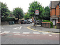
1
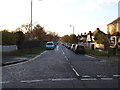
London Borough of Harrow : Lascelles Avenue
Looking towards Lascelles Avenue off Besborough Road.
Image: © Lewis Clarke
Taken: 18 Jul 2019
0.11 miles
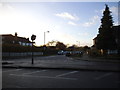
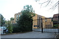
2
Charles Crescent, Harrow
It's no longer a crescent as it's been blocked in the middle.
Image: © David Howard
Taken: 16 Dec 2019
0.12 miles
3

Sunset from Harrow on the Hill
Sunset from Harrow on the Hill October 16th 2011
Image: © Aidan
Taken: 16 Oct 2011
0.13 miles
4
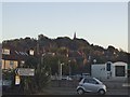
Harrow on the Hill from Bessborough Road
Image: © David Howard
Taken: 28 Oct 2014
0.15 miles
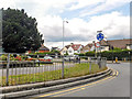
6
London Borough of Harrow : Butler Avenue
Butler Avenue off Bessborough Road.
Image: © Lewis Clarke
Taken: 18 Jul 2019
0.16 miles

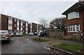
8
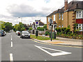
London Borough of Harrow : Whitmore Road
Looking along Whitmore Road from Besborough Road.
Image: © Lewis Clarke
Taken: 18 Jul 2019
0.18 miles