IMAGES TAKEN NEAR TO
Whitehall Road, HARROW, HA1 3BH
Introduction
This page details the photographs taken nearby to Whitehall Road, HA1 3BH by members of the Geograph project.
The Geograph project started in 2005 with the aim of publishing, organising and preserving representative images for every square kilometre of Great Britain, Ireland and the Isle of Man.

There are currently over 7.5m images from over14,400 individuals and you can help contribute to the project by visiting https://www.geograph.org.uk
Image Map
Images are licensed for reuse under creativecommons.org/licenses/by-sa/2.0
Notes
- Clicking on the map will re-center to the selected point.
- The higher the marker number, the further away the image location is from the centre of the postcode.
Image Listing (183 Images Found)
Images are licensed for reuse under creativecommons.org/licenses/by-sa/2.0
Image
Details
Distance

2
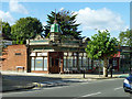
Wards free house
The corner unit of a small parade of shops, all similarly embellished in green tiles and stonework, but without the turret.
Image: © Robin Webster
Taken: 29 Sep 2012
0.05 miles
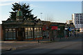
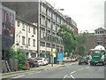
5
Office blocks, Lowlands Road, Harrow-on-the-Hill
Image: © Christopher Hilton
Taken: 20 Jan 2015
0.05 miles
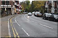
6
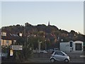
Harrow on the Hill from Bessborough Road
Image: © David Howard
Taken: 28 Oct 2014
0.06 miles
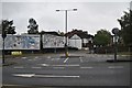
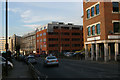
8
London Borough of Harrow : Lowlands Road A404
Heading along Lowlands Road.
Image: © Lewis Clarke
Taken: 18 Jul 2019
0.07 miles

10
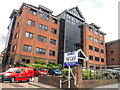
London Borough of Harrow : The Heights
A building on Lowlands Road.
Image: © Lewis Clarke
Taken: 18 Jul 2019
0.07 miles