IMAGES TAKEN NEAR TO
Thurlby Close, HARROW, HA1 2LZ
Introduction
This page details the photographs taken nearby to Thurlby Close, HA1 2LZ by members of the Geograph project.
The Geograph project started in 2005 with the aim of publishing, organising and preserving representative images for every square kilometre of Great Britain, Ireland and the Isle of Man.

There are currently over 7.5m images from over14,400 individuals and you can help contribute to the project by visiting https://www.geograph.org.uk
Image Map
Images are licensed for reuse under creativecommons.org/licenses/by-sa/2.0
Notes
- Clicking on the map will re-center to the selected point.
- The higher the marker number, the further away the image location is from the centre of the postcode.
Image Listing (42 Images Found)
Images are licensed for reuse under creativecommons.org/licenses/by-sa/2.0
Image
Details
Distance
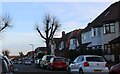
1
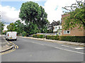
London Borough of Brent : Gayton Road
From Kenton Road looking along Gayton Road.
Image: © Lewis Clarke
Taken: 18 Jul 2019
0.03 miles

5
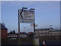
Road sign on Sheepcote Road roundabout
Image: © David Howard
Taken: 11 Dec 2008
0.08 miles
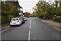
6
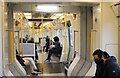
Metropolitan Line train at Northwick Park
Heading east
Image: © David Howard
Taken: 9 Dec 2021
0.09 miles
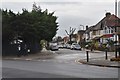
7
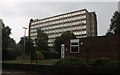
University of Westminster, Harrow campus
Image: © David Howard
Taken: 2 Jul 2020
0.09 miles

10
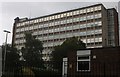
University of Westminster, Harrow campus
Image: © David Howard
Taken: 2 Jul 2020
0.10 miles