IMAGES TAKEN NEAR TO
Torver Road, HARROW, HA1 1TH
Introduction
This page details the photographs taken nearby to Torver Road, HA1 1TH by members of the Geograph project.
The Geograph project started in 2005 with the aim of publishing, organising and preserving representative images for every square kilometre of Great Britain, Ireland and the Isle of Man.

There are currently over 7.5m images from over14,400 individuals and you can help contribute to the project by visiting https://www.geograph.org.uk
Image Map
Images are licensed for reuse under creativecommons.org/licenses/by-sa/2.0
Notes
- Clicking on the map will re-center to the selected point.
- The higher the marker number, the further away the image location is from the centre of the postcode.
Image Listing (40 Images Found)
Images are licensed for reuse under creativecommons.org/licenses/by-sa/2.0
Image
Details
Distance
3
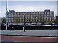
Harrow Civic Centre
The ultimate municipal monolith, and home of Harrow Council! Harrow Council's website is here http://www.harrow.gov.uk/ccm/portal/
Image: © Nigel Cox
Taken: 12 Nov 2005
0.15 miles
5
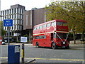
Routemaster at Harrow Civic Centre
Dressed up for wedding duties, Routemaster RMA65 waits. This Routemaster variant was the last one of 65 built with a front entrance and equipped for towing a baggage trailer, for BEA duty from their West London terminal to Heathrow. They were originally in BEA livery, later British Airways after BEA and BOAC merged.
Image: © Robin Webster
Taken: 13 Oct 2012
0.17 miles
6
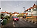
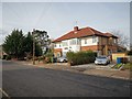
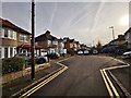
Ranmoor Gardens and Ranmoor Close
Small side roads off Marlborough Hill.
Image: © James Emmans
Taken: 20 Nov 2019
0.17 miles
7
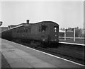
'Oerlikon' electric train at Harrow and Wealdstone, Middlesex
These heavy electric trains, which were in use at this time on the services from Watford Junction to Euston and Broad Street, and also from Broad Street to Richmond, had electrical equipment by the Swiss firm of Oerlikon. They were both reliable and fast, but they caused considerable wear to the tracks, which were shared with London Transport's 'Bakerloo' tube trains. The Oerlikon trains were replaced during 1957-58 with more modern (but much less interesting) stock. These services still continue, nowadays using Class 313 trains.
Image: © Dr Neil Clifton
Taken: 11 Mar 1956
0.19 miles
8
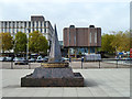
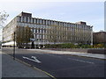
Memorial and civic buildings, Harrow
To paraphrase the inscription, it commemorates those who died fighting for freedom, from Harrow or anywhere else. There is no reference to any particular war or conflict, or whose idea of freedom they were fighting for.
Image: © Robin Webster
Taken: 13 Oct 2012
0.20 miles
10
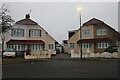
Harrow - Leys Close
Short road off Marlborough Hill. The photo is in HDR mode so picks out the vapour trails very well and better than the human eye.
HDR info: https://en.wikipedia.org/wiki/High-dynamic-range_imaging
Image: © James Emmans
Taken: 20 Nov 2019
0.21 miles