IMAGES TAKEN NEAR TO
Hindes Road, HARROW, HA1 1SQ
Introduction
This page details the photographs taken nearby to Hindes Road, HA1 1SQ by members of the Geograph project.
The Geograph project started in 2005 with the aim of publishing, organising and preserving representative images for every square kilometre of Great Britain, Ireland and the Isle of Man.

There are currently over 7.5m images from over14,400 individuals and you can help contribute to the project by visiting https://www.geograph.org.uk
Image Map
Images are licensed for reuse under creativecommons.org/licenses/by-sa/2.0
Notes
- Clicking on the map will re-center to the selected point.
- The higher the marker number, the further away the image location is from the centre of the postcode.
Image Listing (17 Images Found)
Images are licensed for reuse under creativecommons.org/licenses/by-sa/2.0
Image
Details
Distance
1
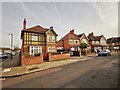
Harrow - Radnor Road
Detached pre-war houses.
Image: © James Emmans
Taken: 20 Nov 2019
0.12 miles
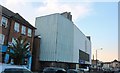
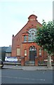
2
Ex church on Angel Road, Harrow
Built in 1904, it's now a nursery
Image: © David Howard
Taken: 11 Aug 2020
0.16 miles
3
Ex church on Angel Road, Harrow
Now used as a nursery
Image: © David Howard
Taken: 11 Aug 2020
0.17 miles
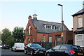
4
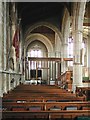
St John the Baptist, Sheepcote Road, Harrow - North aisle
Image: © John Salmon
Taken: 4 Aug 2004
0.17 miles
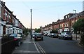
5
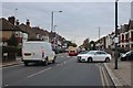
Headstone Road leading into Harrow View
Image: © David Howard
Taken: 16 Dec 2019
0.17 miles
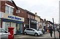
8
Greenhill Way, Harrow
Seen here at the junction with Springfield Road, which is not open to vehicles.
Image: © Stephen McKay
Taken: 26 Jun 2010
0.20 miles