IMAGES TAKEN NEAR TO
Roxborough Road, HARROW, HA1 1PA
Introduction
This page details the photographs taken nearby to Roxborough Road, HA1 1PA by members of the Geograph project.
The Geograph project started in 2005 with the aim of publishing, organising and preserving representative images for every square kilometre of Great Britain, Ireland and the Isle of Man.

There are currently over 7.5m images from over14,400 individuals and you can help contribute to the project by visiting https://www.geograph.org.uk
Image Map
Images are licensed for reuse under creativecommons.org/licenses/by-sa/2.0
Notes
- Clicking on the map will re-center to the selected point.
- The higher the marker number, the further away the image location is from the centre of the postcode.
Image Listing (82 Images Found)
Images are licensed for reuse under creativecommons.org/licenses/by-sa/2.0
Image
Details
Distance
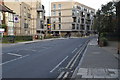
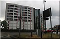
3
Roundabout on Pinner Road, Harrow
After over 20 years they are still building here, I am surprised they can still find room.
Image: © David Howard
Taken: 11 Oct 2014
0.07 miles
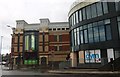
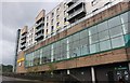
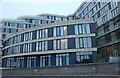
6

Bradstowe House, Harrow
Part of the constant developments going up in Harrow since the 80s.
Image: © David Howard
Taken: 2 Jul 2020
0.07 miles