IMAGES TAKEN NEAR TO
Old Compton Lane, FARNHAM, GU9 8EG
Introduction
This page details the photographs taken nearby to Old Compton Lane, GU9 8EG by members of the Geograph project.
The Geograph project started in 2005 with the aim of publishing, organising and preserving representative images for every square kilometre of Great Britain, Ireland and the Isle of Man.

There are currently over 7.5m images from over14,400 individuals and you can help contribute to the project by visiting https://www.geograph.org.uk
Image Map
Images are licensed for reuse under creativecommons.org/licenses/by-sa/2.0
Notes
- Clicking on the map will re-center to the selected point.
- The higher the marker number, the further away the image location is from the centre of the postcode.
Image Listing (38 Images Found)
Images are licensed for reuse under creativecommons.org/licenses/by-sa/2.0
Image
Details
Distance
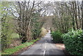
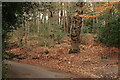
2
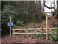
Signposts on Moor Park Way near Farnham
Amongst other things the North Downs Way passes here.
Image: © Shazz
Taken: 6 Mar 2011
0.09 miles
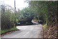
6
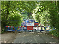
Moor Park Lane is closed
Work to improve sewers has closed the lane, even to pedestrians.
Image: © Robin Webster
Taken: 8 Aug 2015
0.11 miles
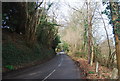
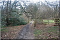
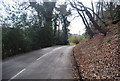
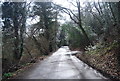
10
Moor Park Way, Compton
This patch of mixed woodland stands beside the road. The road drops, as it approaches the River Wey, leaving a steep bank on the right side of the road.
Image: © Peter Trimming
Taken: 11 Nov 2015
0.15 miles