IMAGES TAKEN NEAR TO
High Park Road, FARNHAM, GU9 7JL
Introduction
This page details the photographs taken nearby to High Park Road, GU9 7JL by members of the Geograph project.
The Geograph project started in 2005 with the aim of publishing, organising and preserving representative images for every square kilometre of Great Britain, Ireland and the Isle of Man.

There are currently over 7.5m images from over14,400 individuals and you can help contribute to the project by visiting https://www.geograph.org.uk
Image Map (Loading...)


Getting Data...Please wait
Leaflet Map data © OpenStreetMap
Images are licensed for reuse under creativecommons.org/licenses/by-sa/2.0
Notes
- Clicking on the map will re-center to the selected point.
- The higher the marker number, the further away the image location is from the centre of the postcode.
Image Listing (363 Images Found)
Images are licensed for reuse under creativecommons.org/licenses/by-sa/2.0
Image
Details
Distance
1
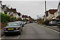
High Park Road, Farnham
Picture taken from beside the bowling club (just out of picture, to the right).
Image: © Peter Trimming
Taken: 11 Nov 2015
0.03 miles
2
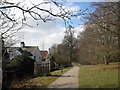
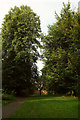
Footpath at Farnham Park
This is the path that runs along the south edge of the park in the area called the Southern Slope.
Image: © don cload
Taken: 10 Mar 2010
0.05 miles
3
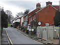
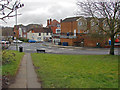
Upper Southview, Farnham
One of the residential roads leading from the town centre to Farnham Park. The barrier at the bottom right surrounds a former industrial site that is being redeveloped for housing.
Image: © Alan Hunt
Taken: 14 Feb 2015
0.06 miles
4
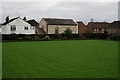
Farnham Bowling Club
Located at the junction of Bear Lane and High Park Road.
Image: © Peter Trimming
Taken: 11 Nov 2015
0.07 miles
5
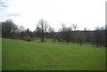
Path, Farnham Park
Farnham footpath 98 approaches the Bear Lane entrance to the park.
Image: © Derek Harper
Taken: 17 Aug 2019
0.07 miles
6

The Old Chapel
Former chapel on Bear Lane
Image: © Richard Croft
Taken: 17 Aug 2010
0.07 miles
8
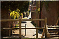
Walkway to Woolmead Road
The walkway from Lower South View to Woolmead Road in Farnham. The junction with East Street and Dogflud Way is in the background.
Image: © Alan Hunt
Taken: 14 Feb 2015
0.08 miles
9

The Old Chapel
Former nonconformist chapel on Bear Lane, now a private house
Image: © Richard Croft
Taken: 17 Aug 2010
0.08 miles
10
Castle Alley
Looking down what has become known as Castle Alley, across Park Row, along Bear Ln heading to South St.
As regards the name “Castle Alley”, it appears the consensus of opinion (the majority) is in favour of this name. Alternatives “Bear Lane”, “Park Row”, “North Alley”, “South alley” etcetera. Any ideas?
Image: © Alan Varndell
Taken: 12 May 2012
0.09 miles