IMAGES TAKEN NEAR TO
Upper Hale Road, FARNHAM, GU9 0JW
Introduction
This page details the photographs taken nearby to Upper Hale Road, GU9 0JW by members of the Geograph project.
The Geograph project started in 2005 with the aim of publishing, organising and preserving representative images for every square kilometre of Great Britain, Ireland and the Isle of Man.

There are currently over 7.5m images from over14,400 individuals and you can help contribute to the project by visiting https://www.geograph.org.uk
Image Map (Loading...)


Getting Data...Please wait
Leaflet Map data © OpenStreetMap
Images are licensed for reuse under creativecommons.org/licenses/by-sa/2.0
Notes
- Clicking on the map will re-center to the selected point.
- The higher the marker number, the further away the image location is from the centre of the postcode.
Image Listing (75 Images Found)
Images are licensed for reuse under creativecommons.org/licenses/by-sa/2.0
Image
Details
Distance
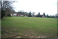
1
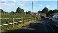
View down Ball and Wicket Lane
Appropriately, the cricket ground can just be seen at the end of the road.
Image: © David Martin
Taken: 8 Jun 2014
0.04 miles
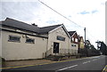
3
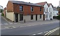
Former Ball and Wicket pub, Upper Hale
A recently-closed pub at the junction of Upper Hale Road and Ball & Wicket Lane. Part of the former pub is now used as Teddy's Bar.
Image: © David960
Taken: 29 Apr 2017
0.05 miles
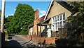
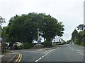
4
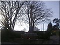
War memorial on the corner of Wings Road
Image: © David Howard
Taken: 13 Mar 2011
0.06 miles
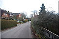
5
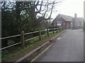
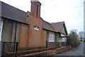
Upper Hale Community Centre, Wings Road
Image: © David Howard
Taken: 13 Mar 2011
0.07 miles