IMAGES TAKEN NEAR TO
Folly Hill, FARNHAM, GU9 0AY
Introduction
This page details the photographs taken nearby to Folly Hill, GU9 0AY by members of the Geograph project.
The Geograph project started in 2005 with the aim of publishing, organising and preserving representative images for every square kilometre of Great Britain, Ireland and the Isle of Man.

There are currently over 7.5m images from over14,400 individuals and you can help contribute to the project by visiting https://www.geograph.org.uk
Image Map (Loading...)


Getting Data...Please wait
Leaflet Map data © OpenStreetMap
Images are licensed for reuse under creativecommons.org/licenses/by-sa/2.0
Notes
- Clicking on the map will re-center to the selected point.
- The higher the marker number, the further away the image location is from the centre of the postcode.
Image Listing (19 Images Found)
Images are licensed for reuse under creativecommons.org/licenses/by-sa/2.0
Image
Details
Distance
1
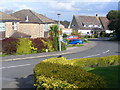
Hampton Road
Modern residential area in a Hale garden suburb - between Aldershot and Farnham.
Image: © Colin Smith
Taken: 30 Mar 2008
0.04 miles
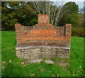
2
Bench on Drovers Way
Ornamental brick bench in suburban Hale. It is engraved "Park View, Residents' Association" and also carries an AD 2000 plaque.
Image: © Colin Smith
Taken: 30 Mar 2008
0.05 miles
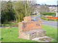
3
Brick seat on the A287
This was last pictured in 2008 - see http://www.geograph.org.uk/photo/746914.
Image: © Shazz
Taken: 15 Oct 2012
0.05 miles
4
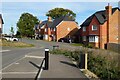
Armsworth Way, Farnham
Viewed from Reeve Drive, part of a new development on the edge of Hale.
Image: © Andrew Smith
Taken: 9 Oct 2022
0.07 miles
5
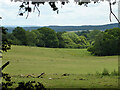
Field, Farnham, 2015 - a lost view
This is now built over by houses on Armsworth Way and roads off it.
Image: © Robin Webster
Taken: 30 Jul 2015
0.10 miles
6
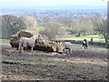
Hale Hay
Feeding time in a field on the south side of Upper Old Park Lane. In the distance is Farnham Park and eastern Farnham.
Image: © Colin Smith
Taken: 30 Mar 2008
0.12 miles
8
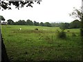
Looking south on Old Park Lane from Upper Old Park Lane
Image: © Shazz
Taken: 15 Oct 2012
0.17 miles
9
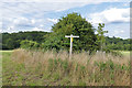
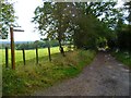
Waymarker, Farnham Park
A waymarker on the public right of way running from Hog Hatch to Farnham Town.
Image: © Alan Hunt
Taken: 15 Aug 2015
0.19 miles
10
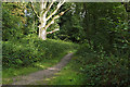
Woodland, Farnham Park
A path cutting through the woods on the northern boundary of Farnham Park.
Image: © Alan Hunt
Taken: 15 Aug 2015
0.21 miles