IMAGES TAKEN NEAR TO
Westbrook Hill, GODALMING, GU8 6LH
Introduction
This page details the photographs taken nearby to Westbrook Hill, GU8 6LH by members of the Geograph project.
The Geograph project started in 2005 with the aim of publishing, organising and preserving representative images for every square kilometre of Great Britain, Ireland and the Isle of Man.

There are currently over 7.5m images from over14,400 individuals and you can help contribute to the project by visiting https://www.geograph.org.uk
Image Map (Loading...)


Getting Data...Please wait
Leaflet Map data © OpenStreetMap
Images are licensed for reuse under creativecommons.org/licenses/by-sa/2.0
Notes
- Clicking on the map will re-center to the selected point.
- The higher the marker number, the further away the image location is from the centre of the postcode.
Image Listing (61 Images Found)
Images are licensed for reuse under creativecommons.org/licenses/by-sa/2.0
Image
Details
Distance
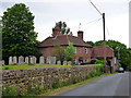
2
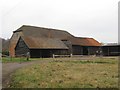
Old farm buildings at Westbrook Farm
Taken in the fading light of a November afternoon. The buildings seen here stand on the W side of a large farmyard, which extends well beyond the frame of the picture, to the right. The low, weather-boarded building nearest the camera looks to me as if it was once a cart-shed, with four bays. The taller, brick-built building on the left has some puzzling features - I mean to have a closer look at it in good daylight, and when I'm in less of a hurry.
Image: © Stefan Czapski
Taken: 19 Nov 2011
0.05 miles
3
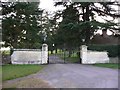
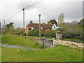
Entrance to Westbrook
This is the main entrance. For the "back" entrance see http://www.geograph.org.uk/photo/2323433.
Image: © Shazz
Taken: 24 Mar 2011
0.06 miles
4
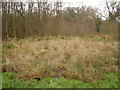
Thundry Meadows
Protected wetlands alongside River Wey at Elstead.
Image: © Malcolm Delahaye
Taken: 29 Jan 2008
0.19 miles
6
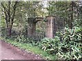
Westbrook drive to lake
The ornamental arch formerly gave access from the formal gardens of Westbrook, the big house on the south side of Westbrook Hill, to the modest lake on the north side. The arch presumably dates from the 1930s, when Sir Albert Levy had the present William-and-Mary-style Westbrook House built. The land to the north, including the lake, appears to have fallen into separate hands, and more recent owners of the house commissioned a lake to be carved out of the hillside to the south of the house. Although there is now a high bank and fence on the south side of the road, opposite the arch, it may be assumed that, in the 1930s, there was a level passage from the house, across the road, to the lake, fit for a stroll on a summer evening, perhaps to take a boat on the lake from the former boathouse.
Image: © Hugh Craddock
Taken: 18 Oct 2020
0.21 miles
7
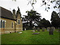
House by the churchyard
Apparently once a farmhouse, as it is called 'Church Farm'.
Image: © Robin Webster
Taken: 31 May 2012
0.22 miles