IMAGES TAKEN NEAR TO
Witley, GODALMING, GU8 5QH
Introduction
This page details the photographs taken nearby to GU8 5QH by members of the Geograph project.
The Geograph project started in 2005 with the aim of publishing, organising and preserving representative images for every square kilometre of Great Britain, Ireland and the Isle of Man.

There are currently over 7.5m images from over14,400 individuals and you can help contribute to the project by visiting https://www.geograph.org.uk
Image Map (Loading...)


Getting Data...Please wait
Leaflet Map data © OpenStreetMap
Images are licensed for reuse under creativecommons.org/licenses/by-sa/2.0
Notes
- Clicking on the map will re-center to the selected point.
- The higher the marker number, the further away the image location is from the centre of the postcode.
Image Listing (7 Images Found)
Images are licensed for reuse under creativecommons.org/licenses/by-sa/2.0
Image
Details
Distance
1
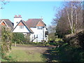
Greensand Way by Parsonage Farm
Long distance path passing a picturesque cottage in the Weald near Brook.
Image: © Colin Smith
Taken: 21 Feb 2009
0.01 miles
2
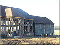
Barn by Parsonage Farm
Construction work (or re-construction?) ongoing beside an old weatherboarded barn which is built on staddle stones to keep its contents safer from rats and mice.
Image: © Colin Smith
Taken: 21 Feb 2009
0.10 miles
3
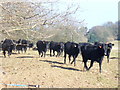
Moove! It's a Photo Shoot!
Inquisitive young black beef cattle head for the camera. This area of the Weald has many grassy fields and patches of woodland.
Image: © Colin Smith
Taken: 21 Feb 2009
0.12 miles
5
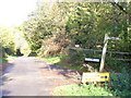
Church Lane, Sandhills
Tree-lined country lane intersection on the Greensand Ridge. Bannacle Hill Road, to the right, leads down to the hamlet of Sandhills.
Image: © Colin Smith
Taken: 7 Nov 2009
0.23 miles
6
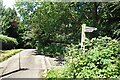
Junction on the Greensand Way
The signpost points the way down the steep hill towards Witley Station.
This is near the west end of the Greensand Way, a long distance path which follows the Lower Greensand ridge from Haslemere to Hamstreet in Kent, a length of 174 kms.
https://en.wikipedia.org/wiki/Greensand_Way
Quite a lot of Greensand is actually visible along the edges of some of these lanes, which have worn down into the soft rock over the centuries.
Image: © Des Blenkinsopp
Taken: 26 Jun 2024
0.24 miles
7
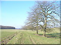
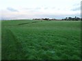
Footpath from Parsonage Farm
Heading north across rolling grassy Wealden fields towards Mare Hill. The fields are set apart by wire fencing.
Image: © Colin Smith
Taken: 21 Feb 2009
0.24 miles