IMAGES TAKEN NEAR TO
Petworth Road, GODALMING, GU8 4ST
Introduction
This page details the photographs taken nearby to Petworth Road, GU8 4ST by members of the Geograph project.
The Geograph project started in 2005 with the aim of publishing, organising and preserving representative images for every square kilometre of Great Britain, Ireland and the Isle of Man.

There are currently over 7.5m images from over14,400 individuals and you can help contribute to the project by visiting https://www.geograph.org.uk
Image Map (Loading...)


Getting Data...Please wait
Leaflet Map data © OpenStreetMap
Images are licensed for reuse under creativecommons.org/licenses/by-sa/2.0
Notes
- Clicking on the map will re-center to the selected point.
- The higher the marker number, the further away the image location is from the centre of the postcode.
Image Listing (23 Images Found)
Images are licensed for reuse under creativecommons.org/licenses/by-sa/2.0
Image
Details
Distance
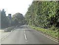
3
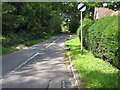
A283 at Ramsnest Common
The Mulberry pub and a Harvest Energy fuel station are ahead on the right.
Image: © Robin Webster
Taken: 25 Oct 2011
0.14 miles
4
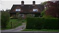
Cottages at Ramsnest Common
These cottages are on the A283.
Image: © Shazz
Taken: 16 Apr 2009
0.15 miles
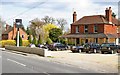
5
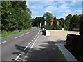
A283 passes The Mulberry
This is also the intriguingly named 'Cripplecrutch Hill'.
Image: © Stuart Logan
Taken: 30 Oct 2012
0.15 miles
6
2020 vision: Day 350
The Mulberry on a December morning
Temperature 8C
BBC Radio Four, 'PM', 17:00 news bulletin, first headline: as cases rise, ministers from all four countries are meeting to discuss the Covid rules relaxation planned for December 23 to December 27
Image: © Basher Eyre
Taken: 15 Dec 2020
0.15 miles
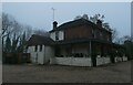
7
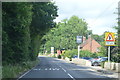
The Mulberry - Restaurant at Ramsnest Common
The restaurant was most likely a Public House at one time and is located on the East side of the A283 close to Chiddingfold.
Image: © Richard Thomas
Taken: 17 Apr 2006
0.17 miles
8
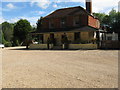
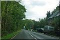
The Mulberry
Formerly a public house now a restaurant.
Image: © Dave Spicer
Taken: 18 Sep 2010
0.17 miles
9
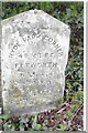
Old Milestone, A283, Cripplecrutch Hill, Ramsnest Common
The milestone, is located 270 m south of the Mulberry Inn on the North West side of the road in the bushes at the back of the verge. Parish of Chiddingfold (Waverley District). Carved stone post, Petworth stone design, erected by the Petworth turnpike trust in the 18th century.
Inscription reads:- HYDE PARK CORNER / 40 MILES / PETWORTH / 7 MILES / GODALMING / 8 MILES / CHIDDINGFOLD / 2 MILES
Milestone Society National ID: SY_LMP40
Image: © George Fitt
Taken: Unknown
0.18 miles