Old Milestone, A283, Cripplecrutch Hill, Ramsnest Common
Introduction
The photograph on this page of Old Milestone, A283, Cripplecrutch Hill, Ramsnest Common by George Fitt as part of the Geograph project.
The Geograph project started in 2005 with the aim of publishing, organising and preserving representative images for every square kilometre of Great Britain, Ireland and the Isle of Man.

There are currently over 7.5m images from over 14,400 individuals and you can help contribute to the project by visiting https://www.geograph.org.uk
Old Milestone, A283, Cripplecrutch Hill, Ramsnest Common
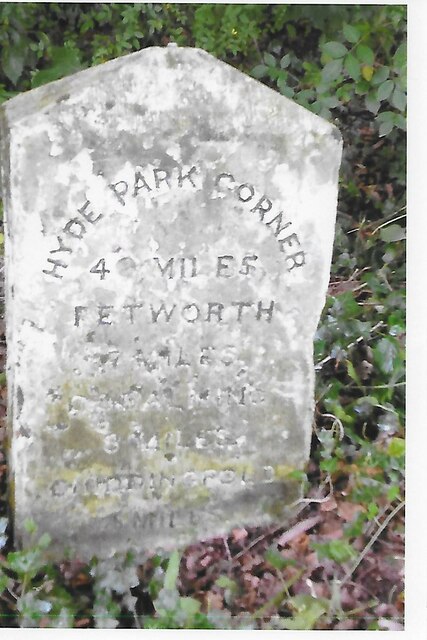
Image: © George Fitt Taken: Unknown
The milestone, is located 270 m south of the Mulberry Inn on the North West side of the road in the bushes at the back of the verge. Parish of Chiddingfold (Waverley District). Carved stone post, Petworth stone design, erected by the Petworth turnpike trust in the 18th century. Inscription reads:- HYDE PARK CORNER / 40 MILES / PETWORTH / 7 MILES / GODALMING / 8 MILES / CHIDDINGFOLD / 2 MILES Milestone Society National ID: SY_LMP40
Images are licensed for reuse under creativecommons.org/licenses/by-sa/2.0
Image Location


Leaflet Map data © OpenStreetMap
Latitude
51.085857
Longitude
-0.647936