IMAGES TAKEN NEAR TO
Binscombe Lane, GODALMING, GU7 3QH
Introduction
This page details the photographs taken nearby to Binscombe Lane, GU7 3QH by members of the Geograph project.
The Geograph project started in 2005 with the aim of publishing, organising and preserving representative images for every square kilometre of Great Britain, Ireland and the Isle of Man.

There are currently over 7.5m images from over14,400 individuals and you can help contribute to the project by visiting https://www.geograph.org.uk
Image Map
Images are licensed for reuse under creativecommons.org/licenses/by-sa/2.0
Notes
- Clicking on the map will re-center to the selected point.
- The higher the marker number, the further away the image location is from the centre of the postcode.
Image Listing (8 Images Found)
Images are licensed for reuse under creativecommons.org/licenses/by-sa/2.0
Image
Details
Distance
1
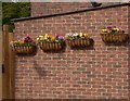
Wallflowers
These flowers brighten a residential street in Binscombe.
Image: © Shazz
Taken: 21 May 2010
0.07 miles
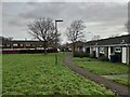
3
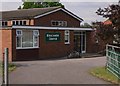
2016: a year on Geograph (Day 182)
Church on the outskirts of Godalming
Image: © Basher Eyre
Taken: 30 Jun 2016
0.09 miles
6
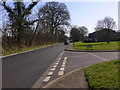
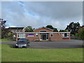
Green Lane at Binscombe
The road on the right is Copse Side.
Image: © Shazz
Taken: 7 Mar 2011
0.24 miles
7
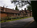
Farm buildings at the north west corner of Binscombe
Image: © Shazz
Taken: 21 May 2010
0.24 miles
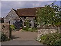
8
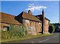
Binscombe Farm
The oldest part of the house is timber-framed with brick in-fill ('nogging') - a form of construction that must once have been very widespread in Surrey, particularly in areas where building stone was hard to come by.
Some examples of brick-nogging in other parts of Surrey:
at Limpsfield http://www.geograph.org.uk/photo/3050766
at Ockley: http://www.geograph.org.uk/photo/2177402
Image: © Stefan Czapski
Taken: 29 Jul 2014
0.25 miles