IMAGES TAKEN NEAR TO
Kings Gate, Kings Road, GODALMING, GU7 3EY
Introduction
This page details the photographs taken nearby to Kings Gate, Kings Road, GU7 3EY by members of the Geograph project.
The Geograph project started in 2005 with the aim of publishing, organising and preserving representative images for every square kilometre of Great Britain, Ireland and the Isle of Man.

There are currently over 7.5m images from over14,400 individuals and you can help contribute to the project by visiting https://www.geograph.org.uk
Image Map (Loading...)


Getting Data...Please wait
Leaflet Map data © OpenStreetMap
Images are licensed for reuse under creativecommons.org/licenses/by-sa/2.0
Notes
- Clicking on the map will re-center to the selected point.
- The higher the marker number, the further away the image location is from the centre of the postcode.
Image Listing (123 Images Found)
Images are licensed for reuse under creativecommons.org/licenses/by-sa/2.0
Image
Details
Distance

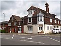
2
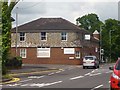
Downs, Farncombe
On the site of the Tanners Arms which closed in 1951.
Image: © David960
Taken: 3 Jun 2014
0.02 miles
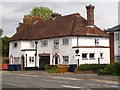
3
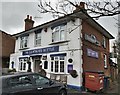
The Leathern Bottle Pub in Farncombe, Surrey
The Leathern Bottle Pub in Farncombe, Surrey next to the A3100, just north of Godalming.
Image: © John P Reeves
Taken: 13 Jan 2020
0.03 miles
4
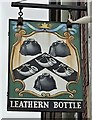
The Leathern Bottle Pub Sign in Farncombe, Surrey
The pub sign of the Leathern Bottle Pub in Farncombe, Surrey next to the A3100, just north of Godalming.
Image: © John P Reeves
Taken: 13 Jan 2020
0.03 miles
6
Sweetapple House
On the corner of Catteshall Road and Meadrow, Farncombe. Once the Catteshall Coffee Tavern: https://www.youtube.com/watch?v=kLxA2p-FKjE
Image: © David960
Taken: 3 Jun 2014
0.05 miles
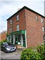
7
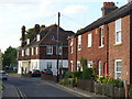
Catteshall Road
Large detached building and a row of red brick cottages near to the road junction with Meadrow.
Image: © Colin Smith
Taken: 3 Sep 2010
0.06 miles
8
Capital House
The former Half Moon pub in Meadrow, Farncombe, closed c.1984.
Image: © David960
Taken: 3 Jun 2014
0.07 miles
9
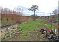
Allotments on north bank of Hell's Ditch
Allotments occupy the strip of land between Hell's Ditch and the buildings along Meadrow. The allotments are part of the Lammas Lands and registered as common land.
Image: © Hugh Craddock
Taken: 1 Apr 2018
0.07 miles
10
T. Andrews & Co
Music and piano shop. Grade II listed: http://www.britishlistedbuildings.co.uk/en-291438-62-and-64-meadrow-godalming-surrey
Image: © David960
Taken: 3 Jun 2014
0.08 miles