IMAGES TAKEN NEAR TO
Wyatts Close, GODALMING, GU7 3DA
Introduction
This page details the photographs taken nearby to Wyatts Close, GU7 3DA by members of the Geograph project.
The Geograph project started in 2005 with the aim of publishing, organising and preserving representative images for every square kilometre of Great Britain, Ireland and the Isle of Man.

There are currently over 7.5m images from over14,400 individuals and you can help contribute to the project by visiting https://www.geograph.org.uk
Image Map (Loading...)


Getting Data...Please wait
Leaflet Map data © OpenStreetMap
Images are licensed for reuse under creativecommons.org/licenses/by-sa/2.0
Notes
- Clicking on the map will re-center to the selected point.
- The higher the marker number, the further away the image location is from the centre of the postcode.
Image Listing (132 Images Found)
Images are licensed for reuse under creativecommons.org/licenses/by-sa/2.0
Image
Details
Distance
2
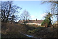
Almshouses located at Wyatts Close
Richard Wyatt Almshouses opened in 1619. See http://www.thecarpenterscompany.co.uk/pages/charities/wyatts_almshouses/default.aspx for information.
Image: © Michael Terry
Taken: 12 Apr 2008
0.03 miles
4
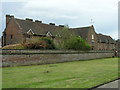
The Wyatt Almshouses, Meadrow
Built in 1622.
An inscription reads as follows:
THIS OYSPITALL WAS
GIVEN BY Mr RICHARD
WYATT OF LONDON
ESQ: FOR TENN POORE
MEN Wth SUFFICIENT
LANDS TO IT FOR Yeir
MAYTENANCE FOR EVEr
The almshouses lie some way back from Meadrow (A3100) and have been supplemented by a good number of dwellings of later date. The ten units of the original building have now been re-arranged to provide eight homes - both for men and women. There is a small central chapel.
Image: © Stefan Czapski
Taken: 31 Jul 2014
0.04 miles
6
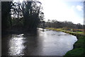
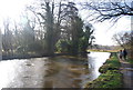
Lammas Lands, Godalming
The large area of floodplain along the River Wey approaching Godalming. They are called Lammas Lands after the commoners right to graze animals after the hay harvest from Lammas Day on August 1st until Lady Day on 25th March
Image: © Alan Hunt
Taken: 22 Aug 2015
0.05 miles
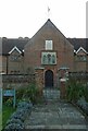
7
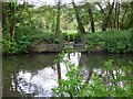
Gateway near Godalming
This is on the River Wey Navigation.
Image: © Shazz
Taken: 21 May 2010
0.05 miles
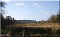
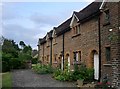
10
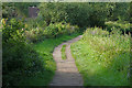
Towpath, River Wey Navigation
The towpath along the River Wey Navigation near Farncombe.
Image: © Alan Hunt
Taken: 22 Aug 2015
0.05 miles