IMAGES TAKEN NEAR TO
Meadrow, GODALMING, GU7 3BZ
Introduction
This page details the photographs taken nearby to Meadrow, GU7 3BZ by members of the Geograph project.
The Geograph project started in 2005 with the aim of publishing, organising and preserving representative images for every square kilometre of Great Britain, Ireland and the Isle of Man.

There are currently over 7.5m images from over14,400 individuals and you can help contribute to the project by visiting https://www.geograph.org.uk
Image Map
Images are licensed for reuse under creativecommons.org/licenses/by-sa/2.0
Notes
- Clicking on the map will re-center to the selected point.
- The higher the marker number, the further away the image location is from the centre of the postcode.
Image Listing (101 Images Found)
Images are licensed for reuse under creativecommons.org/licenses/by-sa/2.0
Image
Details
Distance
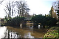
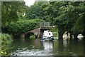
1
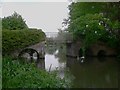
Bridge over the River Wey Navigation
A footpath uses this bridge.
Image: © Shazz
Taken: 21 May 2010
0.01 miles
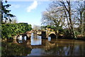
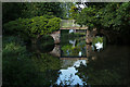
2
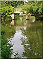
Trower's Bridge - over the Godalming Navigation
Now so overgrown that the shape of the bridge is obscured - see Dr Neil Clifton's contribution, showing the bridge as it was in 1983: http://www.geograph.org.uk/photo/620215
Image: © Stefan Czapski
Taken: 31 Jul 2014
0.02 miles
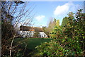
3
Footbridge over Hell Ditch
At the point where Hell Ditch joins the River Wey. In the background is Catteshall Road.
Image: © Ian Capper
Taken: 23 Jun 2012
0.02 miles
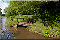
5
Perry Bridge
This footbridge carries the Fox Way over the Wey Navigation.
Image: © N Chadwick
Taken: 27 Jan 2013
0.02 miles
7
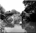
Trowers Footbridge, River Wey, Surrey
In my fieldbook I recorded this as 'Farncombe Bridge', but I am fairly certain it is actually the bridge named on the Geoprojects map as above, especially as this map has the next bridge to the south named as 'Catteshall Bridge'.
Image: © Dr Neil Clifton
Taken: 11 Jun 1978
0.02 miles
8
Trower's Footbridge
Carries a footpath across the canal from Catteshall to Unstead.
Image: © Graham Horn
Taken: 25 Aug 2008
0.03 miles
9
Trower's Bridge, River Wey Navigation
Trower's Bridge viewed from the west.
Image: © Alan Hunt
Taken: 22 Aug 2015
0.03 miles