IMAGES TAKEN NEAR TO
Quartermile Road, GODALMING, GU7 1TJ
Introduction
This page details the photographs taken nearby to Quartermile Road, GU7 1TJ by members of the Geograph project.
The Geograph project started in 2005 with the aim of publishing, organising and preserving representative images for every square kilometre of Great Britain, Ireland and the Isle of Man.

There are currently over 7.5m images from over14,400 individuals and you can help contribute to the project by visiting https://www.geograph.org.uk
Image Map (Loading...)


Getting Data...Please wait
Leaflet Map data © OpenStreetMap
Images are licensed for reuse under creativecommons.org/licenses/by-sa/2.0
Notes
- Clicking on the map will re-center to the selected point.
- The higher the marker number, the further away the image location is from the centre of the postcode.
Image Listing (10 Images Found)
Images are licensed for reuse under creativecommons.org/licenses/by-sa/2.0
Image
Details
Distance
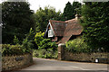
1

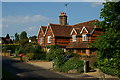
Quarter Mile Road
Houses along Quarter Mile Road, Busbridge.
Image: © Ben Gamble
Taken: 18 Jun 2005
0.06 miles
2
Godalming
Quartermile Road, seen from Home Farm Road.
Image: © Peter Trimming
Taken: 27 Aug 2016
0.07 miles
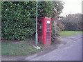
3

Old Boundary Marker on Busbridge Lane, Godalming
Estate Boundary Marker on the east side of Busbridge Lane under vegetation on the south side of the drive of No 123 Wychwood. Godalming parish. Inscribed B for Busbridge Hall on its north face and P.N.G. for Percy North Graham on its front face. Percy North Graham and his family occupied Busbridge Hall from 1906 to 1921. See https://www.andrewsgen.com/photo/godalming/busbridge_hall02.htm.
Milestone Society National ID: SY_GOD03em
Image: © J Hills
Taken: 27 Mar 2021
0.13 miles
4
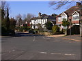
Busbridge Lane
The crossing roads are Park Road to the left and The Drive to the right. There is the end of a twitten on the right of the picture.
Image: © Shazz
Taken: 7 Mar 2011
0.16 miles
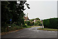
5
Godalming
Entrance to the Busbridge Hall estate, with the north lodge to the right of picture.
Image: © Peter Trimming
Taken: 27 Aug 2016
0.17 miles
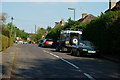
6
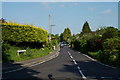
Quartermile Road, Godalming, Surrey
A busy cut through, on the southern edge of Godalming.
Image: © Peter Trimming
Taken: 22 May 2012
0.18 miles
7
Housing on Tuesley Lane, Godalming, Surrey
Looking in the direction of Godalming, with Quarter Mile Road just visible, in the background.
Image: © Peter Trimming
Taken: 22 May 2012
0.20 miles
9

Old Boundary Marker on Tuesley lane, Godalming
Estate Boundary Marker on the east side of Tuesley Lane south of the junction with Park Road under vegetation beside an electricity substation. Inscribed A W. Francis Boyd Shannon Wilder owned Busbridge Hall in the 1840's and A W might record a relative. See https://www.andrewsgen.com/photo/godalming/busbridge_hall02.htm.
Milestone Society National ID: SY_GOD04em
Image: © J Hills
Taken: 27 Mar 2021
0.23 miles
10
Minster Road, Godalming, Surrey
Housing at the southern edge of Godalming.
Image: © Peter Trimming
Taken: 22 May 2012
0.24 miles