IMAGES TAKEN NEAR TO
Penstock Mews, GODALMING, GU7 1NB
Introduction
This page details the photographs taken nearby to Penstock Mews, GU7 1NB by members of the Geograph project.
The Geograph project started in 2005 with the aim of publishing, organising and preserving representative images for every square kilometre of Great Britain, Ireland and the Isle of Man.

There are currently over 7.5m images from over14,400 individuals and you can help contribute to the project by visiting https://www.geograph.org.uk
Image Map
Images are licensed for reuse under creativecommons.org/licenses/by-sa/2.0
Notes
- Clicking on the map will re-center to the selected point.
- The higher the marker number, the further away the image location is from the centre of the postcode.
Image Listing (125 Images Found)
Images are licensed for reuse under creativecommons.org/licenses/by-sa/2.0
Image
Details
Distance
1

River Wey at Catteshall
The river loops past old mills and new housing here, east of the Godalming Navigation cut at Catteshall Lock.
http://www.weyriver.co.uk/theriver/index.htm
Image: © Colin Smith
Taken: 27 Jun 2009
0.00 miles
2

Catteshall from the Wey Navigation
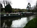
Taken on the canal path on the Wey Navigation as it leaves Godalming en route to Guildford, Surrey, I am looking back to the moorings at Catteshall.
Image: © Carroll Pierce
Taken: 27 Mar 2015
0.01 miles
3
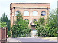
Old Mill, Catteshall
Substantial brick-built former mill on the Wey, Catteshall Road.
Image: © Colin Smith
Taken: 27 Jun 2009
0.02 miles
4
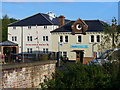
The Mill, Catteshall
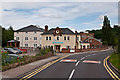
Converted mill buildings near Catteshall Lock on the Godalming Navigation. The old buildings now house a medical practice and a pharmacy.
Image: © Colin Smith
Taken: 3 Sep 2010
0.02 miles
5
Former engine house for Catteshall paper mills
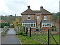
Now residential, along with the rest of the mill site.
Image: © Robin Webster
Taken: 9 Nov 2011
0.02 miles
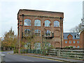
6
Catteshall Mill
A former paper mill redeveloped for light industrial and residential use.
The building on the right was the main beam-engine house in about 1878.
(Surrey Archaeological Society Research Volumes (1981) Volume 8)
Also see Image
Image: © Ian Taylor
Taken: 9 Sep 2017
0.03 miles
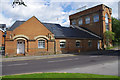
7
Catteshall Road
On the left is the former Mill complex, now a housing a medical practice and chemists, with the remainder, including the Mill Tower in the background, converted for residential use.
Image: © Ian Capper
Taken: 23 Jun 2012
0.05 miles
9
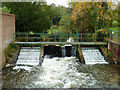
Weir, Catteshall
On the River Wey, upstream of the former mill. The navigable lock cut is 200 m to the right, well out of shot, as is a smaller backwater.
Image: © Robin Webster
Taken: 9 Nov 2011
0.05 miles
10
Catteshall
On the final section of our walk to Godalming from Guildford, Surrey, this is the mooring point at Catteshall.
Image: © Carroll Pierce
Taken: 21 Mar 2014
0.06 miles