IMAGES TAKEN NEAR TO
Copse Lane, CRANLEIGH, GU6 8UP
Introduction
This page details the photographs taken nearby to Copse Lane, GU6 8UP by members of the Geograph project.
The Geograph project started in 2005 with the aim of publishing, organising and preserving representative images for every square kilometre of Great Britain, Ireland and the Isle of Man.

There are currently over 7.5m images from over14,400 individuals and you can help contribute to the project by visiting https://www.geograph.org.uk
Image Map (Loading...)


Getting Data...Please wait
Leaflet Map data © OpenStreetMap
Images are licensed for reuse under creativecommons.org/licenses/by-sa/2.0
Notes
- Clicking on the map will re-center to the selected point.
- The higher the marker number, the further away the image location is from the centre of the postcode.
Image Listing (5 Images Found)
Images are licensed for reuse under creativecommons.org/licenses/by-sa/2.0
Image
Details
Distance
1
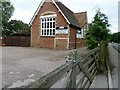
Former Alfold School
Although this northern end is a Day Care and Nursery the remainder of the building is private dwelling.
Image: © Dave Spicer
Taken: 17 Jul 2011
0.07 miles
2
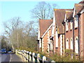
Loxwood Road
The road north from Alfold, lined by the Old School.
Image: © Colin Smith
Taken: 3 Jan 2009
0.19 miles
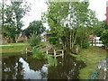
4
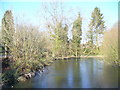
Jubilee Pond, Alfold
Frozen village pond on the east side of Loxwood Road.
Image: © Colin Smith
Taken: 3 Jan 2009
0.22 miles
5
Southern edge of Alfold Pond
Behind is the roadway into Alfold business park.
Image: © Dave Spicer
Taken: 17 Jul 2011
0.24 miles