IMAGES TAKEN NEAR TO
Peaslake Road, CRANLEIGH, GU6 7NT
Introduction
This page details the photographs taken nearby to Peaslake Road, GU6 7NT by members of the Geograph project.
The Geograph project started in 2005 with the aim of publishing, organising and preserving representative images for every square kilometre of Great Britain, Ireland and the Isle of Man.

There are currently over 7.5m images from over14,400 individuals and you can help contribute to the project by visiting https://www.geograph.org.uk
Image Map
Images are licensed for reuse under creativecommons.org/licenses/by-sa/2.0
Notes
- Clicking on the map will re-center to the selected point.
- The higher the marker number, the further away the image location is from the centre of the postcode.
Image Listing (20 Images Found)
Images are licensed for reuse under creativecommons.org/licenses/by-sa/2.0
Image
Details
Distance
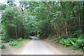
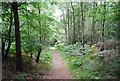
3
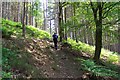
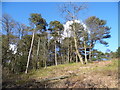
Path through the Hurt Wood
Climbing up from Gasson Farm to the Radnor Road
Image: © Ron Strutt
Taken: 31 May 2003
0.10 miles
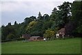
4
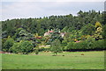
View towards Coverwood
Coverwood is the name both of the wood that runs along the valley side, and also of a large house (not visible from this angle).
Photo taken from the Greensand Way.
Image: © Stefan Czapski
Taken: 13 Apr 2016
0.12 miles
6
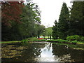
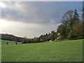
Coverwood Lakes
Access by kind permission of the owner on a National Garden Scheme open day.
Image: © don cload
Taken: 3 May 2009
0.20 miles
10
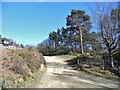
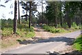
Car park entrance on Radnor Road, Peaslake
Image: © David Howard
Taken: 17 Apr 2016
0.22 miles