IMAGES TAKEN NEAR TO
East Whipley Lane, GUILDFORD, GU5 0TE
Introduction
This page details the photographs taken nearby to East Whipley Lane, GU5 0TE by members of the Geograph project.
The Geograph project started in 2005 with the aim of publishing, organising and preserving representative images for every square kilometre of Great Britain, Ireland and the Isle of Man.

There are currently over 7.5m images from over14,400 individuals and you can help contribute to the project by visiting https://www.geograph.org.uk
Image Map
Images are licensed for reuse under creativecommons.org/licenses/by-sa/2.0
Notes
- Clicking on the map will re-center to the selected point.
- The higher the marker number, the further away the image location is from the centre of the postcode.
Image Listing (11 Images Found)
Images are licensed for reuse under creativecommons.org/licenses/by-sa/2.0
Image
Details
Distance
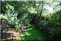
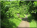
1
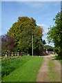
Footpath reaches East Whipley Farm
The autumn colours are coming along nicely.
Image: © Shazz
Taken: 23 Sep 2011
0.06 miles
2
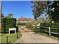
East Whipley Farm
The farmhouse viewed from the passing bridleway.
Image: © Chris Thomas-Atkin
Taken: 30 May 2021
0.09 miles
3
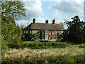
House by East Whipley Farm
Clearly rather more than a farmhouse.
Image: © Robin Webster
Taken: 25 Oct 2011
0.09 miles
4
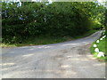
Footpath reaches bridleway east of East Whipley Farm
Image: © Shazz
Taken: 23 Sep 2011
0.10 miles
5
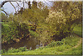
Wey South Path at East Whipley Farm.
The Long Distance Path crosses the stream on the footbridge and parallels the Downslink Path here too. The fields in this valley support cattle and sheep grazing.
Image: © Colin Smith
Taken: 7 May 2006
0.16 miles
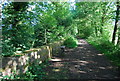
9
Downs Link near Cranleigh
The Downs Link path follows a dismantled railway line for most of its length. It also forms part of route 223 of the National Cycle Network.
An information board alongside the path gives information about the Wey & Arun Canal, which passes beneath the path here. The canal, opened in 1816, linked the Wey and Arun Navigations to provided a navigable route for barges between London and Portsmouth.
Image: © Malc McDonald
Taken: 3 Jun 2022
0.24 miles
10
The Downs Link crosses the Wey Arun Canal
Image: © N Chadwick
Taken: 4 Jul 2010
0.24 miles