IMAGES TAKEN NEAR TO
Christmas Hill, GUILDFORD, GU4 8HN
Introduction
This page details the photographs taken nearby to Christmas Hill, GU4 8HN by members of the Geograph project.
The Geograph project started in 2005 with the aim of publishing, organising and preserving representative images for every square kilometre of Great Britain, Ireland and the Isle of Man.

There are currently over 7.5m images from over14,400 individuals and you can help contribute to the project by visiting https://www.geograph.org.uk
Image Map (Loading...)


Getting Data...Please wait
Leaflet Map data © OpenStreetMap
Images are licensed for reuse under creativecommons.org/licenses/by-sa/2.0
Notes
- Clicking on the map will re-center to the selected point.
- The higher the marker number, the further away the image location is from the centre of the postcode.
Image Listing (48 Images Found)
Images are licensed for reuse under creativecommons.org/licenses/by-sa/2.0
Image
Details
Distance
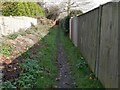
1
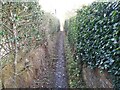
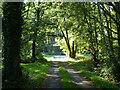
Footpath between Gardens
A view of the public footpath running between private gardens approaching Shalford Common in Shalford, Surrey.
Image: © John P Reeves
Taken: 27 Nov 2020
0.02 miles
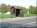
2
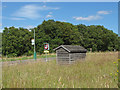
Bus stop, Shalford
The bus stop on the A248 on the edge of Shalford village.
Image: © Alan Hunt
Taken: 14 Jul 2014
0.04 miles
3
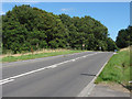
A248, Shalford
The A248 leaving Shalford village on route to Dorking.
Image: © Alan Hunt
Taken: 14 Jul 2014
0.04 miles
4
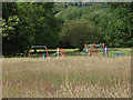
Shalford Common, play area
The children's play area on Shalford Common.
Image: © Alan Hunt
Taken: 14 Jul 2014
0.09 miles
5
House access track, Shalford Common
Looking away from the houses towards A248 Christmas Hill.
Image: © Robin Webster
Taken: 3 Oct 2011
0.10 miles
6
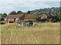
Shalford Common
The houses on the edge of Shalford Common with Guildford's Quarry Hill in the background.
Image: © Alan Hunt
Taken: 14 Jul 2014
0.10 miles
7
Bus shelter at Christmas Hill, Shalford
Image: © Andrew Longton
Taken: 4 May 2006
0.11 miles
8
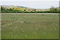
Meadow, Shalford
This view is taken from where the North Downs Way takes a 90 degree turn and looks across meadows towards a gap in the North Downs forged by the River Wey, probably the most important reason for Guildford's location.
Image: © Paul E Smith
Taken: 15 May 2010
0.11 miles
9
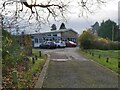
Shalford Village Hall
A view up the drive leading to Shalford Village Hall, situated on the Southern side of Shalford Common in Shalford, Surrey.
Image: © John P Reeves
Taken: 27 Nov 2020
0.11 miles
10
Footpath alongside Gardens
A view of the public footpath running alongside private gardens, running from Chinthurst Lane to Shalford Common in Shalford, Surrey.
Image: © John P Reeves
Taken: 27 Nov 2020
0.12 miles