IMAGES TAKEN NEAR TO
Horsham Road, GUILDFORD, GU4 8EJ
Introduction
This page details the photographs taken nearby to Horsham Road, GU4 8EJ by members of the Geograph project.
The Geograph project started in 2005 with the aim of publishing, organising and preserving representative images for every square kilometre of Great Britain, Ireland and the Isle of Man.

There are currently over 7.5m images from over14,400 individuals and you can help contribute to the project by visiting https://www.geograph.org.uk
Image Map
Images are licensed for reuse under creativecommons.org/licenses/by-sa/2.0
Notes
- Clicking on the map will re-center to the selected point.
- The higher the marker number, the further away the image location is from the centre of the postcode.
Image Listing (67 Images Found)
Images are licensed for reuse under creativecommons.org/licenses/by-sa/2.0
Image
Details
Distance
1
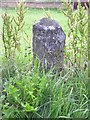
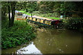
Old Milestone by the A281, Horsham Road, Shalford Parish
Carved stone post by the A281, in parish of SHALFORD (GUILDFORD District), Horsham Road, opposite Stonebridge Wharf, in grass, by bus shelter, on East side of road. Horsham Facet, erected by the Horsham & Guildford (Alfold) turnpike trust in the 19th century.
Inscription reads:- : HORSHAM / 18 MILES : : BRIGHTON / 40 : : (GUILDFORD / 2) :
Milestone Society National ID: SY_BRGF40.
Image: © L Joseph & H&KC
Taken: 13 Sep 2005
0.04 miles
4
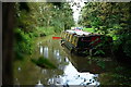
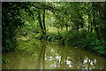
Wey Navigation
Seen from beside the Horsham Road bridge (A281). This is the stub of the former Wey & Arun Canal. The Wey & Arun Canal Trust is developing plans to re-establish the link between the canal and the River Wey.
Image: © Peter Trimming
Taken: 11 Oct 2014
0.11 miles
5
Wey Navigation
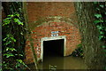
Seen from beside the Horsham Road bridge (A281). This is the stub of the former Wey & Arun Canal, with the canal bridge having been bricked up.
Image: © Peter Trimming
Taken: 11 Oct 2014
0.12 miles
6
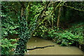
Wey Navigation
Seen from the Horsham Road bridge (A281) at Stonebridge. This is the stub of the former Wey & Arun Canal.
Image: © Peter Trimming
Taken: 11 Oct 2014
0.12 miles
7
Wey Navigation
Seen from beside the Horsham Road bridge (A281). This is the stub of the former Wey & Arun Canal.
Image: © Peter Trimming
Taken: 11 Oct 2014
0.12 miles
8
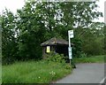
Stub of the Way Navigation
Seen from the Horsham Road, and marked as 'Private Water'.
Image: © Peter Trimming
Taken: 11 Oct 2014
0.12 miles
9
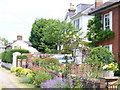
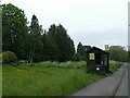
Horsham Road
Cottages and cottage gardens on the main road south from Shalford village.
Image: © Colin Smith
Taken: 4 Jul 2009
0.14 miles
10
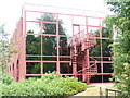
Reflective Scene
Modern business unit at Stonebridge Wharf, Shalford. This is where the Wey & Arun Canal joined the Godalming Navigation.
Image: © Colin Smith
Taken: 4 Jul 2009
0.16 miles