IMAGES TAKEN NEAR TO
The Street, GUILDFORD, GU4 8BT
Introduction
This page details the photographs taken nearby to The Street, GU4 8BT by members of the Geograph project.
The Geograph project started in 2005 with the aim of publishing, organising and preserving representative images for every square kilometre of Great Britain, Ireland and the Isle of Man.

There are currently over 7.5m images from over14,400 individuals and you can help contribute to the project by visiting https://www.geograph.org.uk
Image Map
Images are licensed for reuse under creativecommons.org/licenses/by-sa/2.0
Notes
- Clicking on the map will re-center to the selected point.
- The higher the marker number, the further away the image location is from the centre of the postcode.
Image Listing (160 Images Found)
Images are licensed for reuse under creativecommons.org/licenses/by-sa/2.0
Image
Details
Distance
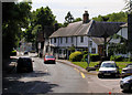
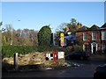
1
Bus stop by the war memorial in Shalford village centre
Image: © Basher Eyre
Taken: 22 Dec 2009
0.01 miles
2
Hexagonal seat in Shalford village centre
Image: © Basher Eyre
Taken: 22 Dec 2009
0.01 miles
3
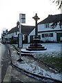
Shalford War Memorial
Outside the parish church, on The Street, the usually busy A281 Guildford-Horsham road.
Image: © Colin Smith
Taken: 4 Jul 2009
0.02 miles
4
Approaching the junction of East Shalford Lane and the A281
Image: © Basher Eyre
Taken: 22 Dec 2009
0.02 miles
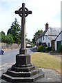
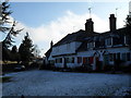
5
The Street, Shalford
This is the A281 looking south in the direction of Bramley. Note the village War Memorial on the right.
Image: © Kevin Gordon
Taken: 24 May 2009
0.03 miles
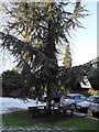
8
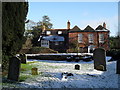
Lingering snow in the churchyard at St Mary, Shalford (6)
Image: © Basher Eyre
Taken: 22 Dec 2009
0.04 miles
9
Postbox at the junction of Church Close and the A281
Image: © Basher Eyre
Taken: 22 Dec 2009
0.04 miles
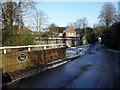
10
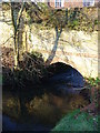
Tilling Bourne, Shalford
The stream here passes below the rebuilt Lemon Bridge on Shalford Lane before flowing under this brick and flint bridge into private grounds. The stream formerly powered several mills, including Chilworth Gunpowder Mills.
Image: © Colin Smith
Taken: 16 Dec 2007
0.04 miles