IMAGES TAKEN NEAR TO
Guernsey Close, GUILDFORD, GU4 7RE
Introduction
This page details the photographs taken nearby to Guernsey Close, GU4 7RE by members of the Geograph project.
The Geograph project started in 2005 with the aim of publishing, organising and preserving representative images for every square kilometre of Great Britain, Ireland and the Isle of Man.

There are currently over 7.5m images from over14,400 individuals and you can help contribute to the project by visiting https://www.geograph.org.uk
Image Map
Images are licensed for reuse under creativecommons.org/licenses/by-sa/2.0
Notes
- Clicking on the map will re-center to the selected point.
- The higher the marker number, the further away the image location is from the centre of the postcode.
Image Listing (60 Images Found)
Images are licensed for reuse under creativecommons.org/licenses/by-sa/2.0
Image
Details
Distance
1
Burpham Ford
This ford is found on Dairyman's Walk at Burpham.
Image: © John Walton
Taken: 10 Nov 2013
0.07 miles
2
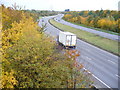
Eastbound A3, Burpham
Taken from the bridge on Clay Lane, looking across deciduous trees towards Ripley. The A3 here is the Guildford By-Pass and is much busier at rush-hour.
Image: © Colin Smith
Taken: 31 Oct 2007
0.08 miles
3
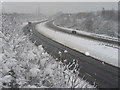
A3, Looking East From Clay Lane
The overnight snowstorm brought chaos to SE England's roads, including the A3 London-Portsmouth road. Several lanes here are obviously closed. Snowploughs were clearing the slush and snow but traffic was much lighter than usual.
Image: © Colin Smith
Taken: 2 Feb 2009
0.11 miles
4
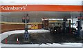
Supertitle, not Subtitle?
Sainsbury's garage at Burpham, Guildford located adjacent to a superstore, is a busy petrol station - except when the snow lies 1 foot deep on the ground!
Image: © Colin Smith
Taken: 2 Feb 2009
0.12 miles
7

St. Luke's Church (2) - east end, Burpham Lane, Burpham, Guildford
Image: © P L Chadwick
Taken: 24 May 2012
0.14 miles
8
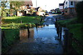
River Wey Navigation near Bowers Lock
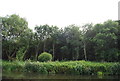
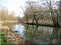
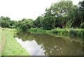
The towpath on the left forms part of the E2 European Long Distance Footpath which runs from Galway to France's Mediterranean coast. Beyond the towpath and further to the left are the woods of the Sutton Place estate. The apparent rural tranquillity is alas not present because of the continuous noise of the traffic from the A3 road which is just beyond the trees to the right.
Image: © Nigel Cox
Taken: 17 Feb 2008
0.14 miles
10
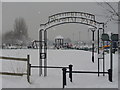
Sutherland Memorial Park
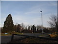
Open grassland in Burpham containing children's playground, football pitches and tennis courts.
Image: © Colin Smith
Taken: 2 Feb 2009
0.15 miles