IMAGES TAKEN NEAR TO
Ryan Mount, SANDHURST, GU47 8JY
Introduction
This page details the photographs taken nearby to Ryan Mount, GU47 8JY by members of the Geograph project.
The Geograph project started in 2005 with the aim of publishing, organising and preserving representative images for every square kilometre of Great Britain, Ireland and the Isle of Man.

There are currently over 7.5m images from over14,400 individuals and you can help contribute to the project by visiting https://www.geograph.org.uk
Image Map
Images are licensed for reuse under creativecommons.org/licenses/by-sa/2.0
Notes
- Clicking on the map will re-center to the selected point.
- The higher the marker number, the further away the image location is from the centre of the postcode.
Image Listing (24 Images Found)
Images are licensed for reuse under creativecommons.org/licenses/by-sa/2.0
Image
Details
Distance
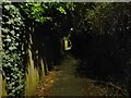
1
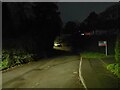
Scotland Hill byway at night
The section of Scotland Hill that is officially a byway. Much of it is laid to tarmac, although around the corner and towards School Hill the road surface is gravel.
Image: © Oscar Taylor
Taken: 28 Mar 2023
0.02 miles
2
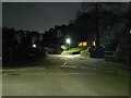
Cock-A-Dobby at night
A cul-de-sac at the top of Scotland Hill, where Scotland Hill becomes a byway. The road has houses built on the steep hill.
Image: © Oscar Taylor
Taken: 28 Mar 2023
0.03 miles
3
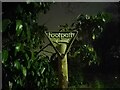
Footpath sign on Scotland Hill at night
A sign denoting the route of the footpath on Scotland Hill. The footpath runs over the railway on a bridge, and leads to Mason Place (to the left at the junction after the railway bridge) and Perryhill Drive (straight on at the junction).
Image: © Oscar Taylor
Taken: 28 Mar 2023
0.06 miles
4
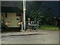
Footpath off Scotland Hill at night
A footpath off Scotland Hill, viewed from the junction of Harts Leap Road. The footpath runs over the railway on a bridge, and leads to Mason Place (to the left at the junction after the railway bridge) and Perryhill Drive (straight on at the junction).
Image: © Oscar Taylor
Taken: 28 Mar 2023
0.06 miles
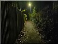
5
Alleyway at night
An alleyway (public footpath) leading from Scotland Hill, over the railway on a bridge, and leads to Mason Place (to the left at the junction after the railway bridge) and Perryhill Drive (straight on at the junction).
Image: © Oscar Taylor
Taken: 28 Mar 2023
0.06 miles
6
Alleyway at night
An alleyway (public footpath) leading from Scotland Hill, over the railway on a bridge, and leads to Mason Place (to the left at the junction after the railway bridge) and Perryhill Drive (straight on at the junction).
Image: © Oscar Taylor
Taken: 28 Mar 2023
0.08 miles
7
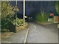
Harts Leap Road at night
A road between Scotland Hill and Crowthorne Road in Sandhurst. The road has intermittent pavements, as do many of the older roads in this part of the town. This section of the road narrows and is difficult for two cars to pass one another. For pedestrians, staying to this side on the left (where the pavement narrows and disappears) is safer as you can use the driveways of the houses to the left if a car does come. The pavement reappears on Scotland Hill.
Image: © Oscar Taylor
Taken: 28 Mar 2023
0.08 miles
8
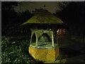
Ancient well on Scotland Hill at night
A well erected in 1874 (so not particularly ancient - that is the name given by Historic England) as a memorial to Harriet Walter Vyvyan of Forest End. It has a cover over the opening fitted in around 2010 when it was last restored. Before that, there was a grille covering the opening.
The structure is a Grade II listed building, list entry number 1390385 https://historicengland.org.uk/listing/the-list/list-entry/1390385
Image: © Oscar Taylor
Taken: 28 Mar 2023
0.08 miles
10
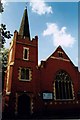
Sandhurst Methodist Church
Built in 1906.
Image: © Michael FORD
Taken: Unknown
0.11 miles