IMAGES TAKEN NEAR TO
New Road, SANDHURST, GU47 8EG
Introduction
This page details the photographs taken nearby to New Road, GU47 8EG by members of the Geograph project.
The Geograph project started in 2005 with the aim of publishing, organising and preserving representative images for every square kilometre of Great Britain, Ireland and the Isle of Man.

There are currently over 7.5m images from over14,400 individuals and you can help contribute to the project by visiting https://www.geograph.org.uk
Image Map
Images are licensed for reuse under creativecommons.org/licenses/by-sa/2.0
Notes
- Clicking on the map will re-center to the selected point.
- The higher the marker number, the further away the image location is from the centre of the postcode.
Image Listing (33 Images Found)
Images are licensed for reuse under creativecommons.org/licenses/by-sa/2.0
Image
Details
Distance
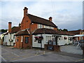
1
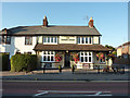
The Dukes Head
Pub on Sandhurst High Street
Image: © Richard Croft
Taken: 13 Sep 2011
0.07 miles
2
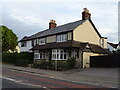
The former Dukes Head on High Street (A321), Sandhurst
Closed in 2014 - now a private residence.
Image: © JThomas
Taken: 28 Jul 2022
0.08 miles
3
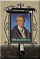
Sign for the former Dukes Head on High Street (A321), Sandhurst
Image: © JThomas
Taken: 28 Jul 2022
0.08 miles
4
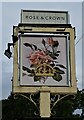
Sign for the Rose & Crown, Sandhurst
See Image] for public house.
Image: © JThomas
Taken: 28 Jul 2022
0.10 miles
5
The Rose & Crown, Sandhurst
On High Street.
See Image] for sign.
Image: © JThomas
Taken: 28 Jul 2022
0.10 miles
6
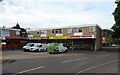
Small shopping centre, Valley View, Sandhurst
Image: © JThomas
Taken: 28 Jul 2022
0.11 miles
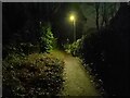
7
Alleyway at night
An alleyway (public footpath) leading from Scotland Hill, over the railway on a bridge, and leads to Mason Place (to the left at the junction after the railway bridge) and Perryhill Drive (straight on at the junction).
Image: © Oscar Taylor
Taken: 28 Mar 2023
0.12 miles
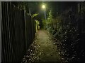
8
Alleyway at night
An alleyway (public footpath) leading from Scotland Hill, over the railway on a bridge, and leads to Mason Place (to the left at the junction after the railway bridge) and Perryhill Drive (straight on at the junction). To the left in this image is the railway, sunk below the level of the path.
Image: © Oscar Taylor
Taken: 28 Mar 2023
0.12 miles
10
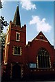
Sandhurst Methodist Church
Built in 1906.
Image: © Michael FORD
Taken: Unknown
0.14 miles