IMAGES TAKEN NEAR TO
Gibbs Lane, BORDON, GU35 9JS
Introduction
This page details the photographs taken nearby to Gibbs Lane, GU35 9JS by members of the Geograph project.
The Geograph project started in 2005 with the aim of publishing, organising and preserving representative images for every square kilometre of Great Britain, Ireland and the Isle of Man.

There are currently over 7.5m images from over14,400 individuals and you can help contribute to the project by visiting https://www.geograph.org.uk
Image Map
Images are licensed for reuse under creativecommons.org/licenses/by-sa/2.0
Notes
- Clicking on the map will re-center to the selected point.
- The higher the marker number, the further away the image location is from the centre of the postcode.
Image Listing (6 Images Found)
Images are licensed for reuse under creativecommons.org/licenses/by-sa/2.0
Image
Details
Distance
1
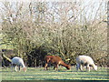
Alpacas by Chestnut Farm
These are obviously rare in the British countryside but they appear to enjoy the winter grazing on this Hampshire farm! In neighbouring Surrey, some farmers near Shere also have alpacas and hire them out for "trekking".
Image: © Colin Smith
Taken: 3 Feb 2007
0.04 miles
3
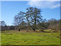
Trees on Shortheath Common
Registered common land and a nature reserve.
Image: © Robin Webster
Taken: 30 Jan 2016
0.10 miles
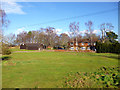
4
Bridleway, Shortheath Common
The bridleway takes riders and walkers to Chestnut Farm and Gibbs Lane.
Image: © Maigheach-gheal
Taken: 1 Nov 2009
0.11 miles
5
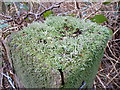
Lichen
Lichen about 1/4 - 1/2 inch deep covers this wooden gate post.
Image: © Colin Smith
Taken: 17 Feb 2007
0.11 miles
6
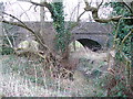
Oakhanger Stream Railway Bridge
This two-arched brick bridge used to carry the Farnham - Bordon railway line.
Image: © Colin Smith
Taken: 17 Feb 2007
0.22 miles