IMAGES TAKEN NEAR TO
Fir Grove, BORDON, GU35 9ED
Introduction
This page details the photographs taken nearby to Fir Grove, GU35 9ED by members of the Geograph project.
The Geograph project started in 2005 with the aim of publishing, organising and preserving representative images for every square kilometre of Great Britain, Ireland and the Isle of Man.

There are currently over 7.5m images from over14,400 individuals and you can help contribute to the project by visiting https://www.geograph.org.uk
Image Map
Images are licensed for reuse under creativecommons.org/licenses/by-sa/2.0
Notes
- Clicking on the map will re-center to the selected point.
- The higher the marker number, the further away the image location is from the centre of the postcode.
Image Listing (3 Images Found)
Images are licensed for reuse under creativecommons.org/licenses/by-sa/2.0
Image
Details
Distance
1
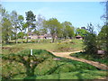
Club House, Blackmoor
Blackmoor Golf Club lies north of the village, west of the larger settlements of Bordon and Whitehill. It occupies heathland.
Image: © Colin Smith
Taken: 21 Apr 2007
0.17 miles
2
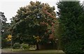
Tree changing colour on Broomfield Road
The road beyond is Hogmoor Road with Hogmoor Inclosure on the far side.
Image: © Shazz
Taken: 9 Oct 2009
0.20 miles
3
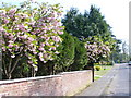
Spring in Whitehill
Suburban Plantation Way in Whitehill, by Bordon, has many bungalows and ornamental trees like these flowering cherries.
Image: © Colin Smith
Taken: 21 Apr 2007
0.20 miles