IMAGES TAKEN NEAR TO
Frensham Lane, BORDON, GU35 8RX
Introduction
This page details the photographs taken nearby to Frensham Lane, GU35 8RX by members of the Geograph project.
The Geograph project started in 2005 with the aim of publishing, organising and preserving representative images for every square kilometre of Great Britain, Ireland and the Isle of Man.

There are currently over 7.5m images from over14,400 individuals and you can help contribute to the project by visiting https://www.geograph.org.uk
Image Map (Loading...)


Getting Data...Please wait
Leaflet Map data © OpenStreetMap
Images are licensed for reuse under creativecommons.org/licenses/by-sa/2.0
Notes
- Clicking on the map will re-center to the selected point.
- The higher the marker number, the further away the image location is from the centre of the postcode.
Image Listing (7 Images Found)
Images are licensed for reuse under creativecommons.org/licenses/by-sa/2.0
Image
Details
Distance
1
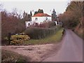
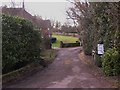
The drive to Linsted Hill leaves Frensham Lane
Linsted Hill is the large house in the picture and the drive reaches it via a large loop. Frensham Lane is in the foreground and all the picture beyond the house sign is in the next grid square.
Image: © Shazz
Taken: 10 Feb 2010
0.12 miles
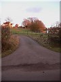
2
Frensham Lane near Linsted Farm
The turning to Linsted Farm, known as Linsted Lane, is on the right.
Image: © Shazz
Taken: 10 Feb 2010
0.12 miles
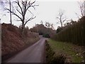
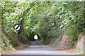
3
Farm road near Arford
The road goes to Linsted (shown as Linstead on Get-a-Map) and Headley Wood Farms.
Image: © Shazz
Taken: 10 Feb 2010
0.16 miles
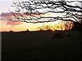
4
Curtis Lane
Sunken lake on the edge of Headley.
Image: © Ben Gamble
Taken: 22 Jul 2005
0.18 miles