IMAGES TAKEN NEAR TO
Standford Hill, BORDON, GU35 8QX
Introduction
This page details the photographs taken nearby to Standford Hill, GU35 8QX by members of the Geograph project.
The Geograph project started in 2005 with the aim of publishing, organising and preserving representative images for every square kilometre of Great Britain, Ireland and the Isle of Man.

There are currently over 7.5m images from over14,400 individuals and you can help contribute to the project by visiting https://www.geograph.org.uk
Image Map (Loading...)


Getting Data...Please wait
Leaflet Map data © OpenStreetMap
Images are licensed for reuse under creativecommons.org/licenses/by-sa/2.0
Notes
- Clicking on the map will re-center to the selected point.
- The higher the marker number, the further away the image location is from the centre of the postcode.
Image Listing (9 Images Found)
Images are licensed for reuse under creativecommons.org/licenses/by-sa/2.0
Image
Details
Distance
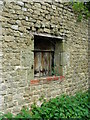
2
The Oast House, Standford Grange, Whitehill Road, Headley, Hampshire
Image: © Oast House Archive
Taken: 13 Mar 2009
0.11 miles
5
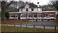
The Robin Hood PH
This is at Standford on the B3044.
Image: © Shazz
Taken: 25 Nov 2008
0.17 miles
6
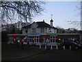
Whiteley's Family Restaurant
Formerly the Robin Hood pub in Standford.
Image: © David960
Taken: 29 Dec 2013
0.19 miles
8
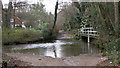
The ford at Standford
The depth is shown at about 2 feet. The top of the scale is 10 feet.
Image: © Shazz
Taken: 25 Nov 2008
0.25 miles
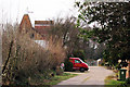
9
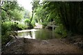
Standford
Ford in Standford. At 2 feet deep, think I'll go around another way.
Image: © Ben Gamble
Taken: 23 Jul 2005
0.25 miles