IMAGES TAKEN NEAR TO
Lower Paice Lane, ALTON, GU34 5PX
Introduction
This page details the photographs taken nearby to Lower Paice Lane, GU34 5PX by members of the Geograph project.
The Geograph project started in 2005 with the aim of publishing, organising and preserving representative images for every square kilometre of Great Britain, Ireland and the Isle of Man.

There are currently over 7.5m images from over14,400 individuals and you can help contribute to the project by visiting https://www.geograph.org.uk
Image Map (Loading...)


Getting Data...Please wait
Leaflet Map data © OpenStreetMap
Images are licensed for reuse under creativecommons.org/licenses/by-sa/2.0
Notes
- Clicking on the map will re-center to the selected point.
- The higher the marker number, the further away the image location is from the centre of the postcode.
Image Listing (7 Images Found)
Images are licensed for reuse under creativecommons.org/licenses/by-sa/2.0
Image
Details
Distance
1
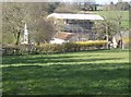
West End Farm
Taken from the minor road to Broadlands, looking north. This shows grazing land in front, sloping down to West End Farm (named on 1:25K maps) at the eastern side of the square. The farm building is completely enclosed by scaffolding and topped with a tarpaulin. Clearly, major work going on here.
Image: © Graham Horn
Taken: 18 Mar 2007
0.17 miles
2
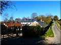
West End Lane at West End Farm
The buildings were subject to major work seven years ago - see http://www.geograph.org.uk/photo/369903.
Image: © Shazz
Taken: 16 Mar 2014
0.19 miles
3
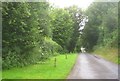
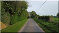
Keep off the verge
West End Lane. What happens if I meet a tractor?
Image: © Fernweh
Taken: 8 Aug 2012
0.23 miles
4
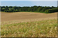
Farmland, Bighton
A large field of barley to the west of West End, Medstead.
Image: © Andrew Smith
Taken: 29 Jun 2024
0.23 miles
5
West End Lane
West End Lane at West End farm.
Image: © Peter Mackenzie
Taken: 23 Apr 2019
0.23 miles
6
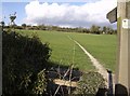
Footpath from West End
Well defined footpath climbing diagonally across the field from a minor road at the western edge of the square.
Image: © Graham Horn
Taken: 18 Mar 2007
0.24 miles
7
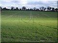
Erratic ploughing
This field has been ploughed on different occasions, in different directions, and it shows. It is currently fallow to grass, the footpath running diagonally across from where the photographer is standing. It shows the dip in the middle of the field with a general slope down from left to right, represented by the U-shaped contour on the map. Along the hedge on the horizon runs Lower Paice Lane (named on 1:25K maps).
Image: © Graham Horn
Taken: 18 Mar 2007
0.24 miles